Berryman eve (pre-race nonsense)
I'd intended to work a half-day on the Friday before Berryman; that would still give me plenty of time to meet Chuck and drive to our campsite in plenty of time to set up before race check-in and the pre-race meeting. When I ended up scoring my favorite sub, though, I went ahead an took the whole day. That gave me time to color my hair Thursday night (priorities!) instead of packing and still only be about 30 minutes late meeting up. (Incidentally, when I mentioned to Jacob how much better I felt with my hair all brown again, he replied, "You have a big gray patch right up front!" Unfortunately he's right, which is obvious in a few of the race pictures. Whatever.)
So we made it to the campground, said hi to a couple other teams at check-in, and proceeded to set up on the wrong campsite. Because we are adventure racers who can't follow a simple campground map. Doh.
Actually, the problem wasn't our map skills (or lack thereof). Chuck misheard the lady who checked us in, while I heard her correctly but assumed that I was wrong, not the last time we'd have that issue over the weekend.
I had brought my backpacking tent, much-loved for its ease of set-up, and was optimistic that the dirt surface would make staking the tent easier than a couple weeks ago at the OT100 race. I was quickly disabused of this notion with the first stake. My tent rested on dirt-covered gravel. Luckily Chuck had a hatchet that we could use to drive in our stakes.
We drove the 20 minutes to race check-in, which was super fast, and then headed off in search of FOOD. We were torn between Mexican and BBQ. Chuck made me pick, so to the surprise of no one who's ever raced with me, Yelp helped us find Sweetwater BBQ.
There was no rush since we'd checked in around 5 and the pre-race meeting didn't start until 8. We camped out at our table and drank way too much soda while looking over the bike drop/gear drop information and trying to guess how the course would run. We headed towards the meeting a little after 7, plenty of time to make the 10-ish minute drive and be early enough to socialize.
Or so we thought.
Having no more stringent navigator duties all day than selecting the pre-set destinations Chuck had already entered, I was once more happily along for the ride as we left my new favorite restaurant and pulled back onto I-44...and completely unprepared when he asked where we were going. I shuffled through the papers Chuck had printed out (sensing a theme here?) until I found the page that listed our destination. We made it to the right road and watched addresses like in the good old pre-GPS days, only to pass where number 1001 should be without any sign of a middle school.
Hmmm.
Since we'd passed a football game, we thought maybe the middle school was behind the field...no such luck. Then we decided maybe we just hadn't driven far enough and drove back down the original road again. Meanwhile, I entered the address into my Google maps, and my phone told us our destination was in the opposite direction. "Turn right..." Siri ordered us. And then, at the bottom of the hill, "Turn right on Smith street [not its real name]." Oops, we passed it.
"Turn left on ____ street." Couldn't make the last-minute turn with traffic behind us.
"Go 2.3 miles and then turn right on ____ street, [you morons]." Siri was definitely starting to take a tone with us.
"That's it!" Chuck said, "I'm turning around."
"Turn left on Smith Street." This time we made our turn, up a treacherous looking gravel hill that made us happy we were in the Jeep. And at the top? We found ourselves right next to the perfectly good paved road the phone had directed us to turn off of.
By this point, my face hurt from laughing so hard. And if you want a good sign of what a good guy Chuck is, he was laughing, too, despite the fact that it's entirely possible that our navigational woes were compounded (or caused) by the fact that I was texting and facebooking with friends while I was supposed to be figuring out where to go. My phone, by the way, sent us back where we'd been twice, and there was still no pre-race meeting there.
Finally I pulled out the directions we'd gotten at race check-in, which unsurprisingly led us right to our destination. In plenty of time, I might add, to say hello to Team Roadkill's Ron and Shawn before taking our seats in the auditorium. After BonkHard called the names of every other person but me in the auditorium to come up and get swag, we got our maps and clue sheets and Gary gave us the rundown on the course and, thanks to the lovely warm temperatures, exempted us from carrying the fleece on our mandatory gear list. Joy! Mine is bulky and takes up too much room in my already stuffed pack.
After the meeting we took advantage of some tables in the hallway and did all of our plotting at the school instead of taking it back to the campground picnic table (or, more likely, a McDonald's table). Usually I read and Chuck plots, but towards the end he stopped suddenly and flipped the map around. "Your turn to plot!" I was not enthused. He's actually the one who taught me to plot points before my very first Berryman, but I'd never actually done it.
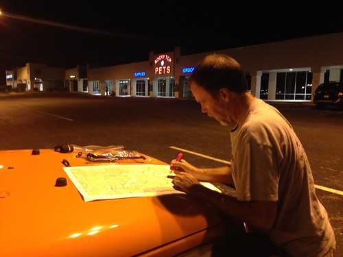
Since the points were on the river, I guess he figured I couldn't screw it up too badly. The school maintenance staff kicked us out before we got a chance to plan our our route, so we headed to McDonald's after all, only to find it packed with post-football game teenagers. No thanks. Instead we made us of street lights and the adventure Jeep.
Mapping finished, we headed back to the campground to ready our packs and get some sleep before the next morning's 5:30 a.m. bike drop. If the days' events didn't inspire much confidence in our navigation, they at least boded well for our likelihood of having a good time, no matter what.
So we made it to the campground, said hi to a couple other teams at check-in, and proceeded to set up on the wrong campsite. Because we are adventure racers who can't follow a simple campground map. Doh.
 |
| Red is where we were supposed to camp; green is where we did camp. Incidentally, I liked the assigned site better. |
I had brought my backpacking tent, much-loved for its ease of set-up, and was optimistic that the dirt surface would make staking the tent easier than a couple weeks ago at the OT100 race. I was quickly disabused of this notion with the first stake. My tent rested on dirt-covered gravel. Luckily Chuck had a hatchet that we could use to drive in our stakes.
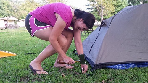 |
| What could possibly go wrong? |
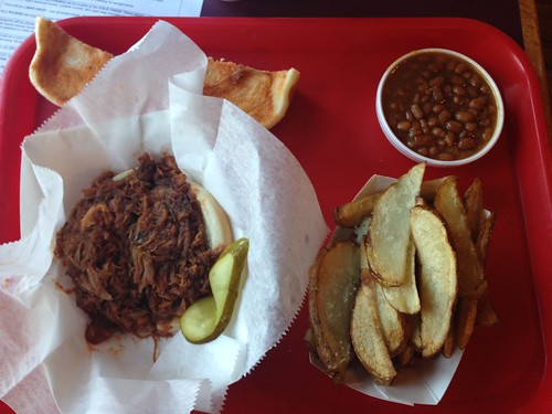 |
| That's what I'm talking about! |
Or so we thought.
Having no more stringent navigator duties all day than selecting the pre-set destinations Chuck had already entered, I was once more happily along for the ride as we left my new favorite restaurant and pulled back onto I-44...and completely unprepared when he asked where we were going. I shuffled through the papers Chuck had printed out (sensing a theme here?) until I found the page that listed our destination. We made it to the right road and watched addresses like in the good old pre-GPS days, only to pass where number 1001 should be without any sign of a middle school.
Hmmm.
Since we'd passed a football game, we thought maybe the middle school was behind the field...no such luck. Then we decided maybe we just hadn't driven far enough and drove back down the original road again. Meanwhile, I entered the address into my Google maps, and my phone told us our destination was in the opposite direction. "Turn right..." Siri ordered us. And then, at the bottom of the hill, "Turn right on Smith street [not its real name]." Oops, we passed it.
"Turn left on ____ street." Couldn't make the last-minute turn with traffic behind us.
"Go 2.3 miles and then turn right on ____ street, [you morons]." Siri was definitely starting to take a tone with us.
"That's it!" Chuck said, "I'm turning around."
"Turn left on Smith Street." This time we made our turn, up a treacherous looking gravel hill that made us happy we were in the Jeep. And at the top? We found ourselves right next to the perfectly good paved road the phone had directed us to turn off of.
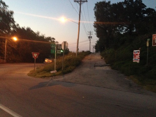 |
| To the left, the good road. To the right, the shitty parallel one the GPS had given us. |
Finally I pulled out the directions we'd gotten at race check-in, which unsurprisingly led us right to our destination. In plenty of time, I might add, to say hello to Team Roadkill's Ron and Shawn before taking our seats in the auditorium. After BonkHard called the names of every other person but me in the auditorium to come up and get swag, we got our maps and clue sheets and Gary gave us the rundown on the course and, thanks to the lovely warm temperatures, exempted us from carrying the fleece on our mandatory gear list. Joy! Mine is bulky and takes up too much room in my already stuffed pack.
After the meeting we took advantage of some tables in the hallway and did all of our plotting at the school instead of taking it back to the campground picnic table (or, more likely, a McDonald's table). Usually I read and Chuck plots, but towards the end he stopped suddenly and flipped the map around. "Your turn to plot!" I was not enthused. He's actually the one who taught me to plot points before my very first Berryman, but I'd never actually done it.
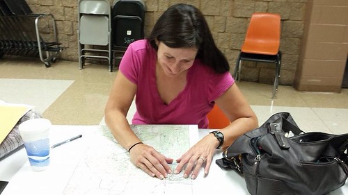 |
| Until now. |
 |
Mapping finished, we headed back to the campground to ready our packs and get some sleep before the next morning's 5:30 a.m. bike drop. If the days' events didn't inspire much confidence in our navigation, they at least boded well for our likelihood of having a good time, no matter what.
FWIW, I think your hair looks nice!
ReplyDeleteThat BBQ looks great! Glad you can laugh at the directions, not sure I could have done that.
ReplyDeleteWhat, you have grey hair? :-)
Sounds like fun for sure.
ReplyDelete