2015 Stubborn Mule 30-hour
Cable, WI, is a long drive from the St. Louis area, but it's totally worth the trip (especially if you aren't the one who does the driving!). This year the Stubborn Mule adventure race moved northwest to the Cable area, and though I was looking forward to the race before I heard about the location change, I was really excited once I started reading about the mountain biking opportunities in the area.
Chuck and Lori picked me up Friday morning and we headed north through lots of rain, an ominous echo of last year's weather that thankfully did not portend another 6-hour midnight downpour during the race. Our hotel was about 2 minutes from the race HQ, which we scouted out between check-in and dinner at the Sawmill Saloon. After dinner we went back to get our bikes and gear as ready as possible, a task that was complicated by the fact that we had no idea how the course would be structured.
Most ARs I've done start with a pre-race meeting the day before where you get your maps and race instructions. That way, you go into race morning having a good idea of where (if at all) you can drop gear and food, how the race is structured, etc. Without a pre-race meeting, I filled my normal pack food pockets and stocked up my bike, then put the rest of my race food in a large ziploc bag until I knew whether I'd be leaving some behind or carrying 30 hours worth of calories with me all day. Aiming for 250 calories an hour, that seemed like a lot of food.
Race check-in started at 4:45 a.m. We received two big maps, a smaller supplemental one, and a packet of CAMBA trail maps. Chuck copied information about private property from master maps while I traced the mandatory bike route on one of the trail maps (first scanning the descriptions and being relieved to see they were rated intermediate) and read over the race book, highlighting mandatory points and time limits. We were left with a few minutes to strategize before the pre-race meeting, where it was my job to be the primary ears for our team.
The race was largely centered around the HQ/start/finish, giving us one place we'd return to repeatedly during the day (with a bathroom! I'm not too ladylike to go in the woods, but not having to was lovely!). This made staging gear super easy. We left extra food, shoes, paddles, and bikes at the HQ and made our way to the start.
6:00 am
Trek 1: 6 CPs, may be obtained in any order, must get 4 or attempt section for 2 hours
The opening jog was a sad reminder that my summer running mileage is anemic at best, but it was impossible to be down in such lovely surroundings.
We got off to a slightly slow start, hampered by the fact that it was difficult to tell the difference between hills and depressions on the map, an issue which might have been mitigated if the navigator's assistant (that would be me) had looked at the clue sheet and mentioned that the clue was "depression". Oops. My bad. It's only been three months since my last adventure race, but apparently my race brain is rusty. That little issue resolved, we knocked out the first four CPs in quick order.
The Chequamegon National Forest has "over 300 miles of marked and mapped routes", which is fantastic. It also means you may well come to an intersection of six trails spidering off into different directions. We hit one such junction on our way to CP5 and spent a longer time that felt right hiking it towards our next CP. At one point we stopped and asked ourselves, if we're not on the right trail, where else on the map are we, but at the time we didn't make the connection that we were on a roughly parallel trail.
In retrospect, we should have stopped, thought it through, and if necessary backed up to reattack, but we kept moving forward until we hit a signed intersection and figured out where we were. At that point we decided to bag CP5 and move on to 6. Hiking along the grassy doubletrack, we saw a black bear on the trail ahead of us.
Holy shit. A bear. One of my enduring disappointments from last year's Stubborn Mule was the complete lack of bear sightings, so once our furry friend ambled along his or her way we were as excited little kids. Seeing a bear totally made up for missing that checkpoint and losing some time. On a high, we collected our final checkpoint and made our way back to race HQ.
Chuck: The bear was definitely a highlight for me too. We all watched each other for a few minutes while Kate got her camera up and running. The bear flicked his ears a few times and shifted his weight around projecting an image of total curiosity. Finally deciding that this IS a bear we started making some noise, then he ran off just like the experts say its supposed to work.
After each leg of the race, teams checked in and out with volunteers. This meant race staff were able to keep track of how many CPs each team had throughout the race, plus they also tracked our transition times, which is interesting information for post-race analysis (that said, while I typically love to start talking about how the race went and what we could do better next time as soon as it's over, this time most of my post-race was spent asleep in the back seat of Chuck and Lori's van).
Trek 1:
Time: 3:27
Distance covered: 9 miles
Checkpoints: 5/6
***
9:39 a.m. (3:39 of racing down, about 26 to go)
Paddle 1: 6 CPs, may be obtained in any order; teams must obtain at least 4/6
We now had a long flat-water paddle on the lovely (and enormous) Lake Namakegon. I'm still no fan of paddling, but like last year, the canoes were some of the nicest I've ever used in a race. I'd say the first three-fourths of the paddle weren't terrible at all. Chuck's nav was flawless, and while we aren't fast paddlers we weren't super slow, either.
At one point we crossed paths with a three-person team. Since the canoes only have front and back seats, the person in the middle is stuck on the bottom unless they bring something to sit on. I was that unlucky person last year, enduring a long river paddle which perched on my pack, so I commiserated with the guy in the middle, telling him I knew it was no fun.
"Yeah," he responded, "but you weren't paddling!" (That's what I get for revealing my "if I'm taking pictures I can't paddle" strategy in last year's race report. :D)
We'd toyed with getting the four mandatory CPs and then heading back to HQ, but somehow we decided to get a fifth as well. I think Chuck even left it up to me, and far be it from me to add to my canoe time, but I wasn't feeling awful at the time. That changed not long after we pointed ourselves towards that last CP. My shoulders and back were sore, my hands were hurting, and I kept shifting position because my legs were uncomfortable. Additionally, lake traffic picked up as the day went on, and it seemed like every jet ski and pontoon boat was making a point to knock us around with their wake. I was very happy to get back to the beach and out of the canoe.
Paddle 1:
Time: 3:59
Distance covered: 14 miles
Checkpoints: 5/6
***
Once again we checked back in with the volunteers and then prepared for the bike leg. We had a 25-mile bike to a new transition area with a 19-CP trekking leg, followed by a 34-mile bike leg back to HQ. We weren't going to be back at HQ until early the next morning, so we loaded up with extra food, stuck our trekking shoes in our packs, and climbed onto our bikes.
2:01 p.m. (8 hours of racing down, 22 to go)
Bike 1: 5 CPs, may be obtained in any order; teams must obtain at least 2/5 CPs
Yes! The bike leg! If there's anything I was trained for post-Dirty Kanza, it was this. We started on pavement/gravel, ticking off miles and our first checkpoint. We had to stop and check the maps to figure out the right turn for our next checkpoint, discovering at that point that we'd lost the map where we'd marked the mandatory bike route. We biked down to a trailhead and looked over the map posted there, noticing Lori's van in the parking area and looking forward to seeing her along the way.
It looked like we could either take the singletrack or a little bit more road. "Let's take the road," I suggested, "Look how squiggly the singletrack is...the road will be way more direct." That may have been true, but once we turned towards the trail the road got super rough. The trail, once we hit it, was buttery smooth and so much fun. Bad call on my part, made worse by the fact that Lori was waiting to cheer and take pictures on the section of singletrack we'd missed.
Chuck: Not a bad call on your part, I was down with it too. It was the best call with the limited information we had.
The trails alone made the 10-hour drive to Wisconsin totally worth it. This section of the race included the Flow Mama and Seeley Pass trails, the swoopiest fun I've ever had on a mountain bike. The three CPs on the singletrack were unmapped; you just had to keep an eye out for them as you rode. We snagged the High Point CP and then spent most of our remaining time on the trails swinging between savoring the trails and worrying we'd missed the other CPs (sometimes doing both at once, because we're overachievers like that). We did get some reassurance when we ran into another team (Marine One, maybe) at a trail intersection. "How many checkpoints have you found on the singletrack?" I asked.
"Just one," they replied. "Everybody else has said the same thing." Whew.
Having missed us at the beginning of the singletrack, Lori found us towards the end and got a couple of pictures on the bike. Usually in an adventure race, by the time one leg ends I'm ready to be doing something new; not this time! I could have stayed on those trails for way longer. Definitely the most fun I've ever had on singletrack. We pulled into the TA with huge smiles on our faces.
Bike 1:
Time: 3:46
Distance covered: 24.4 miles
Checkpoints: 5/5
***
Trek 2: 19 CPs, may be obtained in any order; teams must obtain at least 8 CPs or attempt course for 3 hours
As we reached the TA, we saw WEDALI running back in to get more water. "Take your time," Emily warned us, "The terrain is really subtle. It's tricky." We pulled on trekking pants, changed shoes, and reapplied bug repellent, then I topped off our water while Chuck looked over our new map. Knowing we weren't going to be clearing the course, we immediately discounted a couple CPs that had almost no contour lines to help with the nav and then identified two different circles of CPs; we'd complete one, then re-evaluate what we wanted to do next.
6:15 p.m. (12 hours of racing down, 18 to go). It's numbers like that that tell you 30 hours is a long time to race.
This trekking leg was centered around the famous Birkie Trail. One section of the Birkie was overlaid on our maps, but no other trails were. This would have baffled me, but once again Chuck nailed the nav. As we completed our first loop, we passed near the TA again on the Birkie, and stopping to check a trail map saw yet another black bear ahead of us on the trail. With dusk starting to fall, I was slightly less excited about seeing the bear, really not wanting to encounter one in the dark.
We saw one 4-person team as we hiked back onto the Birkie from our first CP of the trek, and then we never saw another person until running into the Marine team on our approach to our last CP. Here we encountered the thickest vegetation of the race, thankfully able to follow their path to the CP but having to break our own trail when we decided to go north towards the road instead of backtracking.
Chuck: And, she really means "BREAK" our own trail, the vegetation was straight out of some jungle movie, a machete would not have been out of place.
Moving in full dark now with only the light of our headlamps to help us find the clearest path, Chuck took us slowly and steadily towards the road. At one point I looked back and thought I saw eyes reflecting my headlamp, and every time he stopped to look at the map I heard weird noises behind me. I was increasingly paranoid about bears. While I'm not a fan of three-person teams and being stuck in the middle of the canoe, at that point I wished desperately for a third teammate so that the bear I imagined behind us could eat them instead of me. Possibly my happiest moment of the race was when we popped out on the road unmauled.
Trek 2:
Time: 4:05
Distance covered: ?
Checkpoints: 9/19
***
Hike-a-Bike: 10 CPs, may be obtained by bike or foot; teams must obtain at least 2 CPs
The TA had moved into the Birkie warming huts, which made a nice place for us to plot the CPs given to us when we checked in. This next section was billed as "Hike-a-Bike". Again we were to cover a combination of gravel and singletrack. Paula, the race director, was at the TA and pointed out to everyone that our CAMBA trail maps would help greatly to find some of the points. Thankfully the map we needed wasn't the one we'd already lost! After Chuck plotted our points, we went over them again with the trail map, also marking that with our route. While I'd been at sea with the topo map, at least the nav on the trail map made sense to me.
11:10 p.m. (17 hours of racing down, 13 to go).
While all CPs could be obtained by either bike or foot, what it boiled down to for us (and most teams, I imagine) was biking to the attack point, dropping bikes, and hiking in to find the point. For our first CP, on a peninsula, we questioned ourselves and had to crawl a log over a creek three times before we went far enough to find the flag. We then somehow missed a turn to our next CP ("Hilltop"), deciding to skip it when we finally figured out where we were.
We found the marsh CP with only one false start, and things got interesting. Attacking too early for CP B9 ("Lake"), we then moved off our bearing in search of our target. Being in the wrong place, we naturally didn't find it, and our wandering around resulted in a slightly disconcerting period where we couldn't see our bike lights and didn't know how to get back to the road. I thought we might have to wait til dawn to figure it out, but Chuck sat down with the map for a minute, got things straight, and led us back out. Once we got back on the road, the actual attack point was just a little bit further, and we and the Wolseley Wanderers located it without further drama.
Chuck: In vegetation that thick, and that late at night, I should not have taken us off a solid bearing in some vague hope of spotting a CP. (I wonder now, in hindsight, if that poor decision was influenced by the beginning of my 'dark time' on the bike leg.) To our great relief, spreading all the maps out on the forest floor and plotting a safety bearing to intersect the road worked out perfectly . This was a great lesson learned.
Subsequent bike CPs were on singletrack, and though I'd been really excited to get back on the awesome CAMBA trails (and thrilled that we'd be riding "easy" trails in the dark), the reality was less joyous than our earlier ride. The trail may have been easy, but it was also boring. My increasing sleepiness was revealed by the way my bike was weaving back and forth across the trail. Still, I was thrilled to be on the bike rather than on foot or in a canoe.
Chuck, on the other hand, hasn't spent as much time on the bike lately. With a previous long ride of around 20 miles, he suffered quietly throughout most of this leg. Since I had a pretty good handle on the (uncomplicated) singetrack nav, Chuck was able to retreat to the pain cave for a while, emerging right as we hit our final trail and just in time for my attitude to go south.
Chuck: And that's why AR is such a great team sport! Everyone goes through a time where they have to depend on their teammates. Kate did outstanding leading us through that section.
I'd been excited about riding another IMBA Epic designee, but despite the fact that daylight had broken and the trail was easier than almost anything we have locally, I somehow began riding (and feeling) like I'd never been on a mountain bike. Meanwhile, Chuck was zipping along the trail like a kid just let out for recess.
We finally got to the end of the trail, where one of us noticed that the cover of one of Chuck's red blinkies was missing. I mentioned that I'd seen it back on the trail, not realizing it was his. "Where was it?" he demanded, "That's my best light!"
"I don't know...it was a ways back," I mumbled vaguely, watching in disbelief as he turned his bike and rode back towards the trail. I thought he was just joking about going back for the light, but he kept going.
"Come on!"
I stared at his back, still trying to formulate the words to nicely tell my teammate that there was no way in hell I was turning around for his stupid taillight when he looked back at me with a big grin and turned us back towards the race HQ.
Chuck: Evidence that I was out of the 'dark time' and Kate was in one. She is usually way to quick to get caught by something that easy.
Hike-a-Bike:
Time: 7:40
Distance covered: 30-ish? miles
Checkpoints: 8/10
***
Paddle 2: 10 miles, 4 cps, any order; teams must get at least 1.
7:17 a.m. (25 hours of racing down, 5 to go).
The volunteers at HQ gave us coordinates for four paddling CPs. It was mandatory to get one, but there were three that were allegedly "pretty close together". We grudgingly grabbed the paddles and trudged back to the canoe beach, only realizing after we'd chosen our boat that our map was back at HQ. I sat in a beach chair and almost fell asleep while Chuck retrieved our map.
The lake was beautiful in the morning light, flat and calm with no sign of the pontoon boats and jet skis that had plagued us the previous morning. Still, the first part of the paddle was terrible as we both fought with sleep. A combination of chocolate-covered espresso beans and conversation helped the situation, but the paddle quickly revealed that my idea and Chuck's idea of "pretty close together" are wildly different. Still, we stuck with our plan of getting the three closest CPs, all of which needed a question answered to prove you were there, and were both thrilled to finally limp back to the beach.
We were very not thrilled when we turned in our passport and answers and were told we'd written the wrong number down for one of the questions. We'd miscounted the number of 2x6's that made up a bench on one of the docks, so we didn't get credit for that CP. Rules are rules, and everyone else had gotten the question right, so it was our mistake not to get out of the canoe onto the dock and count more carefully, but I was pissed we'd done all that paddling for nothing. Definitely my least happy moment of the race.
Paddle 2:
Time: 2:19
Distance covered: 8? miles
Checkpoints: 2/4
***
9:48 a.m. (28 hours of racing down, 2 to go).
Trek 3: 9 CPs, all optional; 4.5 miles
The volunteers gave us our final set of coordinates to plot for the final trek. We knew we didn't have time to get all of them, so we picked the closest ones and headed out. We found the first one, located on a beautiful open grassy hilltop (you'll have to take my word for it since I left the camera back at HQ), pretty quickly. The second, located at the end of a boardwalk in the middle of a marsh, proved much more difficult as we got distracted by a small marsh along our bearing. Eventually we found it, and since it was another question/answer CP, I made Chuck double check my answer.
There was one more CP in close proximity, but after the issues we'd had with our last one we decided not to take any chances with the hour we had left. Instead, we headed back to the finish line, which we found with no problem.
Trek 3:
Time: 1:25
Distance covered: not all that far
Checkpoints: 2/9
11:13 a.m. (29:13 total race time).
Even better than finishing the race was the fact that we were able to immediately use the showers at the resort hosting the race, brush our teeth, and then eat. I know I've been grosser during a race (Thunder Rolls 2013!), but I've never wanted a shower as badly as I did this year.
Chuck and Lori picked me up Friday morning and we headed north through lots of rain, an ominous echo of last year's weather that thankfully did not portend another 6-hour midnight downpour during the race. Our hotel was about 2 minutes from the race HQ, which we scouted out between check-in and dinner at the Sawmill Saloon. After dinner we went back to get our bikes and gear as ready as possible, a task that was complicated by the fact that we had no idea how the course would be structured.
Most ARs I've done start with a pre-race meeting the day before where you get your maps and race instructions. That way, you go into race morning having a good idea of where (if at all) you can drop gear and food, how the race is structured, etc. Without a pre-race meeting, I filled my normal pack food pockets and stocked up my bike, then put the rest of my race food in a large ziploc bag until I knew whether I'd be leaving some behind or carrying 30 hours worth of calories with me all day. Aiming for 250 calories an hour, that seemed like a lot of food.
Race check-in started at 4:45 a.m. We received two big maps, a smaller supplemental one, and a packet of CAMBA trail maps. Chuck copied information about private property from master maps while I traced the mandatory bike route on one of the trail maps (first scanning the descriptions and being relieved to see they were rated intermediate) and read over the race book, highlighting mandatory points and time limits. We were left with a few minutes to strategize before the pre-race meeting, where it was my job to be the primary ears for our team.
The race was largely centered around the HQ/start/finish, giving us one place we'd return to repeatedly during the day (with a bathroom! I'm not too ladylike to go in the woods, but not having to was lovely!). This made staging gear super easy. We left extra food, shoes, paddles, and bikes at the HQ and made our way to the start.
 |
| Photo credit: Stubborn Mule AR WEDALI up front, Chuck and I waaaaaay in the back on the right. :) |
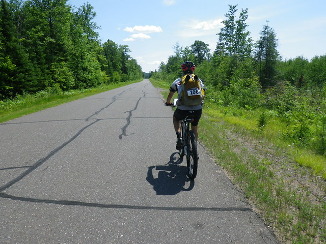
Trek 1: 6 CPs, may be obtained in any order, must get 4 or attempt section for 2 hours
The opening jog was a sad reminder that my summer running mileage is anemic at best, but it was impossible to be down in such lovely surroundings.
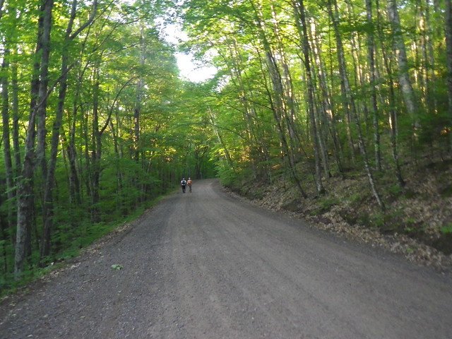 |
| Nice way to start the day |
 |
| Getting CP4 |
In retrospect, we should have stopped, thought it through, and if necessary backed up to reattack, but we kept moving forward until we hit a signed intersection and figured out where we were. At that point we decided to bag CP5 and move on to 6. Hiking along the grassy doubletrack, we saw a black bear on the trail ahead of us.
Not too long into our race this weekend, Chuck and I came across this bear. It stood in the trail for a minute or two and then ran off into the woods. It peered over at us from the side as we passed, but before I could get my camera out again it lost interest. We actually saw a second bear later that day, maybe around 4 or 5 in a different area.
Posted by Kate Lavelle Geisen on Monday, June 29, 2015
Holy shit. A bear. One of my enduring disappointments from last year's Stubborn Mule was the complete lack of bear sightings, so once our furry friend ambled along his or her way we were as excited little kids. Seeing a bear totally made up for missing that checkpoint and losing some time. On a high, we collected our final checkpoint and made our way back to race HQ.
Chuck: The bear was definitely a highlight for me too. We all watched each other for a few minutes while Kate got her camera up and running. The bear flicked his ears a few times and shifted his weight around projecting an image of total curiosity. Finally deciding that this IS a bear we started making some noise, then he ran off just like the experts say its supposed to work.
After each leg of the race, teams checked in and out with volunteers. This meant race staff were able to keep track of how many CPs each team had throughout the race, plus they also tracked our transition times, which is interesting information for post-race analysis (that said, while I typically love to start talking about how the race went and what we could do better next time as soon as it's over, this time most of my post-race was spent asleep in the back seat of Chuck and Lori's van).
Trek 1:
Time: 3:27
Distance covered: 9 miles
Checkpoints: 5/6
***
9:39 a.m. (3:39 of racing down, about 26 to go)
Paddle 1: 6 CPs, may be obtained in any order; teams must obtain at least 4/6
We now had a long flat-water paddle on the lovely (and enormous) Lake Namakegon. I'm still no fan of paddling, but like last year, the canoes were some of the nicest I've ever used in a race. I'd say the first three-fourths of the paddle weren't terrible at all. Chuck's nav was flawless, and while we aren't fast paddlers we weren't super slow, either.
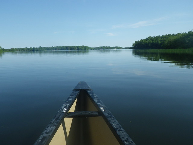 |
| Water like glass |
"Yeah," he responded, "but you weren't paddling!" (That's what I get for revealing my "if I'm taking pictures I can't paddle" strategy in last year's race report. :D)
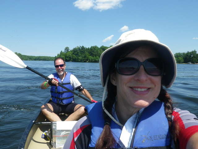 |
| This smile may not be entirely sincere. Also, not the less smooth water. |
 |
| Get me out of this effing boat. Photo credit: Lori Vohsen |
Time: 3:59
Distance covered: 14 miles
Checkpoints: 5/6
***
 |
| Happily switching from paddle mode to bike mode. Photo credit: Lori Vohsen |
2:01 p.m. (8 hours of racing down, 22 to go)
Bike 1: 5 CPs, may be obtained in any order; teams must obtain at least 2/5 CPs
 |
| Chuck at the beginning of the bike leg |
Yes! The bike leg! If there's anything I was trained for post-Dirty Kanza, it was this. We started on pavement/gravel, ticking off miles and our first checkpoint. We had to stop and check the maps to figure out the right turn for our next checkpoint, discovering at that point that we'd lost the map where we'd marked the mandatory bike route. We biked down to a trailhead and looked over the map posted there, noticing Lori's van in the parking area and looking forward to seeing her along the way.
It looked like we could either take the singletrack or a little bit more road. "Let's take the road," I suggested, "Look how squiggly the singletrack is...the road will be way more direct." That may have been true, but once we turned towards the trail the road got super rough. The trail, once we hit it, was buttery smooth and so much fun. Bad call on my part, made worse by the fact that Lori was waiting to cheer and take pictures on the section of singletrack we'd missed.
Chuck: Not a bad call on your part, I was down with it too. It was the best call with the limited information we had.
 |
| "Is this Heaven?" "No, this is Wisconsin." |
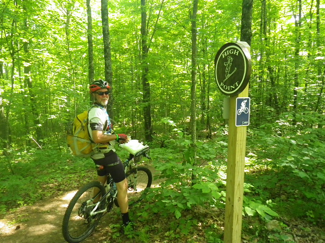 |
| Highest point on the trail (maybe in the area...I've forgotten now) |
"Just one," they replied. "Everybody else has said the same thing." Whew.
 |
| Finishing up Seeley Pass trail |
Having missed us at the beginning of the singletrack, Lori found us towards the end and got a couple of pictures on the bike. Usually in an adventure race, by the time one leg ends I'm ready to be doing something new; not this time! I could have stayed on those trails for way longer. Definitely the most fun I've ever had on singletrack. We pulled into the TA with huge smiles on our faces.
Bike 1:
Time: 3:46
Distance covered: 24.4 miles
Checkpoints: 5/5
***
Trek 2: 19 CPs, may be obtained in any order; teams must obtain at least 8 CPs or attempt course for 3 hours
As we reached the TA, we saw WEDALI running back in to get more water. "Take your time," Emily warned us, "The terrain is really subtle. It's tricky." We pulled on trekking pants, changed shoes, and reapplied bug repellent, then I topped off our water while Chuck looked over our new map. Knowing we weren't going to be clearing the course, we immediately discounted a couple CPs that had almost no contour lines to help with the nav and then identified two different circles of CPs; we'd complete one, then re-evaluate what we wanted to do next.
 |
| And we're off! |
6:15 p.m. (12 hours of racing down, 18 to go). It's numbers like that that tell you 30 hours is a long time to race.
This trekking leg was centered around the famous Birkie Trail. One section of the Birkie was overlaid on our maps, but no other trails were. This would have baffled me, but once again Chuck nailed the nav. As we completed our first loop, we passed near the TA again on the Birkie, and stopping to check a trail map saw yet another black bear ahead of us on the trail. With dusk starting to fall, I was slightly less excited about seeing the bear, really not wanting to encounter one in the dark.
We saw one 4-person team as we hiked back onto the Birkie from our first CP of the trek, and then we never saw another person until running into the Marine team on our approach to our last CP. Here we encountered the thickest vegetation of the race, thankfully able to follow their path to the CP but having to break our own trail when we decided to go north towards the road instead of backtracking.
Chuck: And, she really means "BREAK" our own trail, the vegetation was straight out of some jungle movie, a machete would not have been out of place.
Moving in full dark now with only the light of our headlamps to help us find the clearest path, Chuck took us slowly and steadily towards the road. At one point I looked back and thought I saw eyes reflecting my headlamp, and every time he stopped to look at the map I heard weird noises behind me. I was increasingly paranoid about bears. While I'm not a fan of three-person teams and being stuck in the middle of the canoe, at that point I wished desperately for a third teammate so that the bear I imagined behind us could eat them instead of me. Possibly my happiest moment of the race was when we popped out on the road unmauled.
Trek 2:
Time: 4:05
Distance covered: ?
Checkpoints: 9/19
***
Hike-a-Bike: 10 CPs, may be obtained by bike or foot; teams must obtain at least 2 CPs
The TA had moved into the Birkie warming huts, which made a nice place for us to plot the CPs given to us when we checked in. This next section was billed as "Hike-a-Bike". Again we were to cover a combination of gravel and singletrack. Paula, the race director, was at the TA and pointed out to everyone that our CAMBA trail maps would help greatly to find some of the points. Thankfully the map we needed wasn't the one we'd already lost! After Chuck plotted our points, we went over them again with the trail map, also marking that with our route. While I'd been at sea with the topo map, at least the nav on the trail map made sense to me.
11:10 p.m. (17 hours of racing down, 13 to go).
While all CPs could be obtained by either bike or foot, what it boiled down to for us (and most teams, I imagine) was biking to the attack point, dropping bikes, and hiking in to find the point. For our first CP, on a peninsula, we questioned ourselves and had to crawl a log over a creek three times before we went far enough to find the flag. We then somehow missed a turn to our next CP ("Hilltop"), deciding to skip it when we finally figured out where we were.
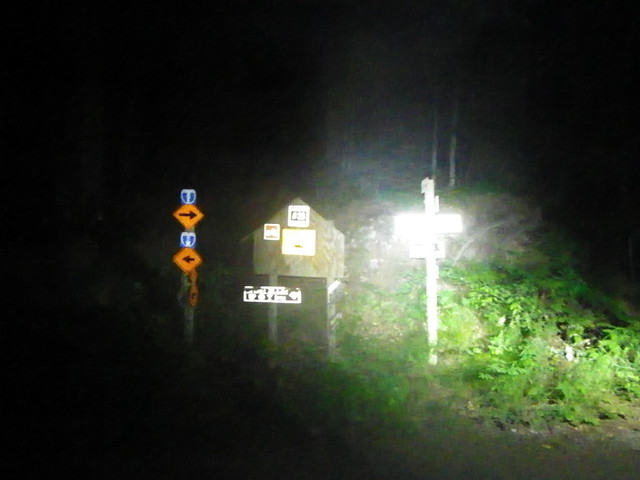 |
| Lots of signs at 1 a.m. The large trail map (not shown) to the right of this picture was really helpful. |
We found the marsh CP with only one false start, and things got interesting. Attacking too early for CP B9 ("Lake"), we then moved off our bearing in search of our target. Being in the wrong place, we naturally didn't find it, and our wandering around resulted in a slightly disconcerting period where we couldn't see our bike lights and didn't know how to get back to the road. I thought we might have to wait til dawn to figure it out, but Chuck sat down with the map for a minute, got things straight, and led us back out. Once we got back on the road, the actual attack point was just a little bit further, and we and the Wolseley Wanderers located it without further drama.
Chuck: In vegetation that thick, and that late at night, I should not have taken us off a solid bearing in some vague hope of spotting a CP. (I wonder now, in hindsight, if that poor decision was influenced by the beginning of my 'dark time' on the bike leg.) To our great relief, spreading all the maps out on the forest floor and plotting a safety bearing to intersect the road worked out perfectly . This was a great lesson learned.
Subsequent bike CPs were on singletrack, and though I'd been really excited to get back on the awesome CAMBA trails (and thrilled that we'd be riding "easy" trails in the dark), the reality was less joyous than our earlier ride. The trail may have been easy, but it was also boring. My increasing sleepiness was revealed by the way my bike was weaving back and forth across the trail. Still, I was thrilled to be on the bike rather than on foot or in a canoe.
Chuck, on the other hand, hasn't spent as much time on the bike lately. With a previous long ride of around 20 miles, he suffered quietly throughout most of this leg. Since I had a pretty good handle on the (uncomplicated) singetrack nav, Chuck was able to retreat to the pain cave for a while, emerging right as we hit our final trail and just in time for my attitude to go south.
Chuck: And that's why AR is such a great team sport! Everyone goes through a time where they have to depend on their teammates. Kate did outstanding leading us through that section.
I'd been excited about riding another IMBA Epic designee, but despite the fact that daylight had broken and the trail was easier than almost anything we have locally, I somehow began riding (and feeling) like I'd never been on a mountain bike. Meanwhile, Chuck was zipping along the trail like a kid just let out for recess.
We finally got to the end of the trail, where one of us noticed that the cover of one of Chuck's red blinkies was missing. I mentioned that I'd seen it back on the trail, not realizing it was his. "Where was it?" he demanded, "That's my best light!"
"I don't know...it was a ways back," I mumbled vaguely, watching in disbelief as he turned his bike and rode back towards the trail. I thought he was just joking about going back for the light, but he kept going.
"Come on!"
I stared at his back, still trying to formulate the words to nicely tell my teammate that there was no way in hell I was turning around for his stupid taillight when he looked back at me with a big grin and turned us back towards the race HQ.
Chuck: Evidence that I was out of the 'dark time' and Kate was in one. She is usually way to quick to get caught by something that easy.
Hike-a-Bike:
Time: 7:40
Distance covered: 30-ish? miles
Checkpoints: 8/10
***
Paddle 2: 10 miles, 4 cps, any order; teams must get at least 1.
7:17 a.m. (25 hours of racing down, 5 to go).
The volunteers at HQ gave us coordinates for four paddling CPs. It was mandatory to get one, but there were three that were allegedly "pretty close together". We grudgingly grabbed the paddles and trudged back to the canoe beach, only realizing after we'd chosen our boat that our map was back at HQ. I sat in a beach chair and almost fell asleep while Chuck retrieved our map.
The lake was beautiful in the morning light, flat and calm with no sign of the pontoon boats and jet skis that had plagued us the previous morning. Still, the first part of the paddle was terrible as we both fought with sleep. A combination of chocolate-covered espresso beans and conversation helped the situation, but the paddle quickly revealed that my idea and Chuck's idea of "pretty close together" are wildly different. Still, we stuck with our plan of getting the three closest CPs, all of which needed a question answered to prove you were there, and were both thrilled to finally limp back to the beach.
 |
| Paddle done, just one...more...leg... |
Paddle 2:
Time: 2:19
Distance covered: 8? miles
Checkpoints: 2/4
***
9:48 a.m. (28 hours of racing down, 2 to go).
Trek 3: 9 CPs, all optional; 4.5 miles
 |
| Plotting and strategizing...and eating Pringles. |
The volunteers gave us our final set of coordinates to plot for the final trek. We knew we didn't have time to get all of them, so we picked the closest ones and headed out. We found the first one, located on a beautiful open grassy hilltop (you'll have to take my word for it since I left the camera back at HQ), pretty quickly. The second, located at the end of a boardwalk in the middle of a marsh, proved much more difficult as we got distracted by a small marsh along our bearing. Eventually we found it, and since it was another question/answer CP, I made Chuck double check my answer.
There was one more CP in close proximity, but after the issues we'd had with our last one we decided not to take any chances with the hour we had left. Instead, we headed back to the finish line, which we found with no problem.
Trek 3:
Time: 1:25
Distance covered: not all that far
Checkpoints: 2/9
 |
| Second in my growing set of Stubborn Mule coasters! |
11:13 a.m. (29:13 total race time).
Even better than finishing the race was the fact that we were able to immediately use the showers at the resort hosting the race, brush our teeth, and then eat. I know I've been grosser during a race (Thunder Rolls 2013!), but I've never wanted a shower as badly as I did this year.
 |
| Showers...and food (lots of food)... |
 |
| ...and beer. Now we're happy. |
We ended up finishing first in our division and 8th overall. Had we gotten credit for the paddle CP where we answered the question wrong, we'd have been 6th overall. Either way, we had a great race.
If you have any way of making it to next year's Stubborn Mule, you really should. The location is incredible, and the race director and volunteers are fantastic. The race is so well-planned and the logistics both years I've raced it have been flawless. Seriously. Do this race. Your only regret will be waiting this long.
Chuck: Oh yeah, I'm definitely IN for next year!
Chuck: Oh yeah, I'm definitely IN for next year!


Another awesome adventure, this one with a bear! Can't beat that. Glad it didn't eat you.
ReplyDeleteWhat an epic adventure, and seeing bears is so cool.
ReplyDeleteI am so glad you do these things, I can read your blog and decide that you are brave and I am a couch potato. Thank you (and excellent bear!)
ReplyDeletep.s Blogger really not wanting me to comment - may appear 5 times.
I cannot believe what you succeed in doing. You don't have limits, everything is possible for you. Congrats Superstar!!!!!
ReplyDeleteAhhhh SK, I love coming over and reading about another adventurous adventure. And double bonus when it's super lengthy (since I relate and all :)) and I have to read it in parts. I swear, you should write a book. The blog is great, but a book - a BOOK - for all to read. And you'd make moola :).
ReplyDeleteI'm glad to read you're doing so well and your head seems to be in a great place this summer. Keep being the SK hero that I know and love!!
xo