Mission (Impossible) 18 hour AR
The Mission 18 Hour is an adventure race put on by D.IN.O (Do INdiana Offroad), and though I've wanted to do it for a long time, its position between Cedar Cross and Dirty Kanza made it problematic family-wise. They're pretty tolerant, but three out of four weekends out of town is a little much. Being on Mother’s Day makes it difficult, too. I have to thank my super-supportive
(tolerant?) wife for giving me clearance to race! Tolerant? She's a freaking saint. And being the mom in my house means I can sign up for the race with zero guilt. I mean, it's my weekend, right?
Having never done the race, I spent the trip to Indiana scouring Attackpoint and Emily's blog for race reports while Mickey drove. The racer update had mentioned a Friday night prologue that would be used to seed teams for the next day, and neither of us was sure exactly how that would work. Other than my failure to answer the question, the only other hiccup on our drive was the realization that the race was in the Eastern time zone and we'd be losing an hour.
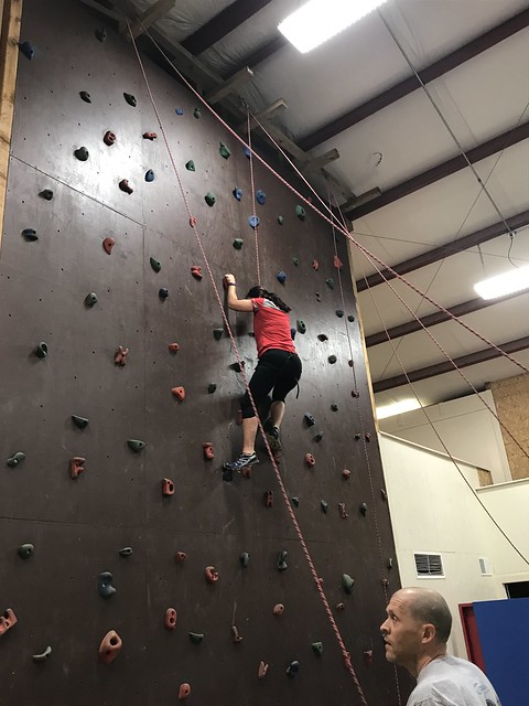
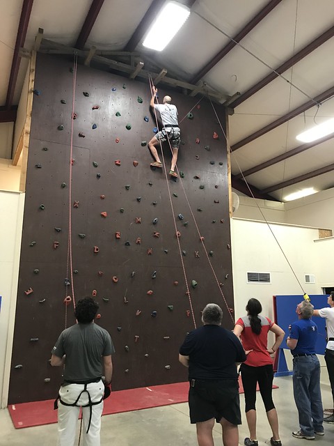
We still made it to race HQ at Hilltop Christian Camp in time to check-in, grab a bite to eat, and visit with some friends before the pre-race meeting, which was short and informative. Brian gave some notes on the course and intermediate cut-offs, confirmed that we wouldn't get maps until the race start, explained that we'd only get the coordinates and instructions for one leg at a time, and told us that the prologue was a climbing wall. Teams would be timed climbing all three lines on the wall, and those times would determine the order in which we received our maps.
We unloaded our gear and readied the packs before heading to the climbing wall, but the line was still long enough for me to work up a pretty good sense of impending doom. Thankfully Mickey offered to do two of the lines, leaving me the easiest one to muddle through. He zipped right up; I had a little trouble starting but made slow and steady progress to the top. After all my dread about the climbing part, it was being lowered back down that scared me the most. Like most things adventure racing forces me to do, though, once it was over it was kind of fun to have done it.
With no plotting or route planning to do, it was a pretty stress-free race eve. Mickey was happier about this than I was -- no pre-plotting meant that our later arrival wasn't a disadvantage. I prefer to know what the course looks like ahead of time -- but did enjoy sleeping in until nearly five the next morning. I absolutely LOVED not having maps (or really any information) beforehand. Usually, I lay in bed the night before running through the course over & over & over and “wake up” tired. It was nice to not do that (although I still didn’t really sleep), and I feel like it added to the adventure only getting one segment of the course at a time.
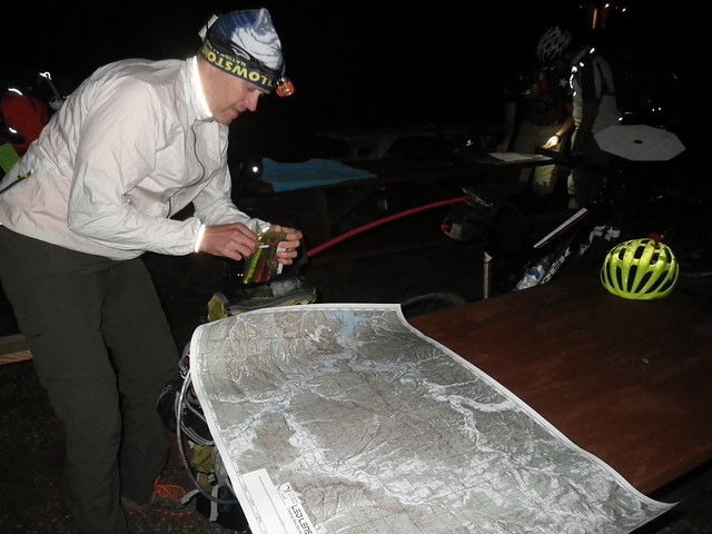
Just before six we converged on the start. Our prologue had put us about mid-pack in the map line; within a minute or two we were plotting the nine points for leg 1. Route planning was pretty straightforward*, and then it was onto the bikes and uphill (of course) out of the camp.
Leg 1: Bike ~ Trek ~ Bike CP 1-8
Even with the bike tow (best invention ever) that first hill was tough. We turned out of camp and Mickey quickly realized we weren't where he expected to be. The road names on the map (rare in my AR experience) made it pretty easy to figure out our location, and he adjusted on the fly. Even with our unexpected reroute, we passed a few teams on the first short bike.
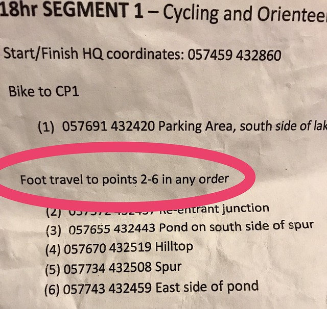
We dropped our bikes with the volunteers, who told us they'd punch CP1 when we returned from our trek. Mickey offered me the map but I passed, not comfortable doing the nav on the 1:25000 scale. "OK," I told him, "We have to get 2-6 in order.*"
We went straight to CP2 with no problems and then confidently set off towards CP3, crossing the creek* and heading up the right* spur. Except...
Hmmm...that looks just like the witness tree we passed on the way here.
"We shouldn't be going in this direction."
"We should be on the east side of the creek."
We did a lot of wandering trying to figure out where we'd gone wrong, at one point running into another 2p coed team who was looking for CP2. We'd just come from there, so we were pretty sure they were in the wrong place*, but we didn't have a good enough handle on where we were to know that for sure, and since they were confused as well they were no real help for us.
Finally we decided to try to find our way back to CP2 and reset, running into my friends Jeff and Rusty on the way. They were coming from 3 on their way to 2. Which, if you have to get the points in order, is cheating...and they aren't cheaters. "Um, don't you have to go in order?" we asked, but I was already pulling out the race instructions.
So I'm an idiot, but the good news is that after an hour of frustration and fruitless searching, we knew where we were and were back on track*. Mickey shot a bearing, and before long we were passing that witness tree again. This time it only took us 10 minutes to catch our mistake.
Looking at the picture of the map, my *guess* is that it’s the printing on the map that threw me off. I use a thumb compass and usually fold my map, so I don’t look at much more than the area between where I am and where I’m trying to get. Also, I’m used to the text on a map lining up with North. If you look at the picture, the word “FOREST” is the main printing between CP2 & CP3, and it’s not lined with North. It’s lined up with West, 90* off what I would expect. I’m not sure that explains why I kept trying to go South when I wanted to go East, but my head is spinning, so I’m going to quit thinking about it.
Mickey was frustrated with our error and not interested in talking about skipping points. One of my concerns about teaming up was our very different abilities and race philosophies. He's far stronger and faster than I am; he's more competitive, too, and was definitely not ready to concede the possibility that we could clear the course. I like to do the best I can, but I race for the fun of it and if I had a tagline it would probably be "you know we're not going to clear this course".
Anyway, I shut up about skipping points for the moment, and we had a clean approach to CP4. Then we overshot our attack point for CP5, covering the wrong spur twice in our search for the PVC checkpoint marker before following it all the way up to the road. With time getting short, we decided to pass on CP5 in order to collect the harder to miss 6 on the way back to our bikes. We might have had time to get 5 as well, but in the end we made it back to the TA with 15 minutes to spare, and given our shaky start that was no sure thing.
We'd shot ourselves in the foot with easily avoidable mistakes but still had plenty of race left, and a lot can happen in 18 hours. We punched CP1 and got back on the bike for the remainder of leg 1. Mickey did a good job of telling me about upcoming turns and things to watch for. We made good use of tow except on big downhills, where I was too nervous to stay attached. Of course, this then meant I didn't have the assist on subsequent uphills. It's something I need to work on.
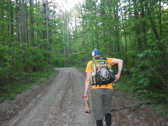
We turned from the gravel onto singletrack and followed that through a super muddy section onto smoother trail and to our attack point for CP7, which was plotted off the trail down a spur. We dropped our bikes and started hiking. Though the CP appeared to be plotted on an old trail, we found no such thing, and my decision to take off my trekking pants for the bike leg immediately proved to be a poor one. Thorns shredded my legs as I chased behind Mickey, cursing the race director for his sadistic CP placement.
We got way further down the spur than we should have with no sign of the CP, so we retraced our steps, each taking a side of the spur and looking carefully for our point. Finding nothing (other than more scratches), we returned to the bikes and looked at the map. Was it possible we weren't at the right spot? We rode further up the trail with no luck, so we decided to go all the way back to the road and try again.
Luckily, we reached our initial attack point at the same time another team arrived there. They were very sure of their spot, which made it likely that we'd been in the right place all along, so we decided that 6 pairs of eyes were better than two. Mickey and I started ahead of the other team (me still in shorts because I'm a slow learner) and almost immediately hit a trail we hadn't seen before, following that directly to the CP. Looking at the maps after the race, it was clear that we'd originally walked down the wrong spur, a mistake I should have caught back at the bikes since I'd done the same thing in February at the Meramec O meet.
The maps had an overlay directing us down the trail and back to the road we'd take to our next TA. So easy...just follow the trail*. We had several spots of confusion when we arrived at unmarked turns. Looking at the map now other trails and turns are evident, but during the race I at least was focused on just the overlay and didn't notice them. We ended up missing a turn and weren't entirely sure where we were when we finally popped out onto the road, but with a little guesswork, a really big hill, and one more missed turn we finally reached the TA.
Leg 2: Paddle ~ CP 9-12
Only 3 or 4 lonely canoes were left in the field, and the 4-person team we'd seen back at CP 7 needed two of them. While I've been in last or near-last place plenty of times, it's still a little demoralizing. The volunteer gave us the coordinates for the paddle leg and told us, "We're all out of PFDs. The race director knows that, so you have permission to do the paddle without them."
You know me; I'm a safety girl. I can swim, but I still wasn't too happy with this news. "So, uh, how deep is this water we're going to be paddling in?" I asked.
"Well," he replied, "If you're worried about it you should probably wait for a PFD."
Instead, we plotted our points, immediately deciding to skip the ones that required a long paddle in the wrong direction. Paddling is not one of our strengths as a team, and with our shaky navigational start we wanted to maximize daylight for our trek from the take-out back to the bike drop. Decisions made and still unhappily (on my part) PFD'less, we said goodbye to the volunteer and dragged our canoe to the creek.
By "we dragged", I mean that Mickey dragged it and I followed with the maps. That was awesome. Less awesome was when we got the canoe into the creek, climbed in, and I tried handing him the maps. "What are you doing? I can't steer and nav! You're doing the paddle nav."
The good news is that we were much smoother with steering and I almost never thought tipping was imminent, very unlike the much colder paddle in our first AR together. The bad news is that I suck at navigating on flooded creeks. I couldn't paddle and look at the map and compass, and landmarks I was watching for, particularly places where the creek came really close to the road, were obscured by flooding. Well, except for the bridge we didn't realize was THE bridge we were looking for.
The subsequent good news, though, is that we ended up much farther along the paddle than I'd thought we were. And we were very fortunate to hit the spot where the creek split while that four-person team we'd met up with earlier was still there to explain to me where we were. Otherwise we might still be on the creek. We ended up unintentionally missing CP9 as well as CPs 10 and 11 which we'd intended to skip, but in retrospect I think the smart race decision for us was to skip them all.
Once we knew where we were again (thanks, other team!) I did a decent job of keeping track of our progress and navigating to the take-out -- well, other than a suboptimal route up to the boat ramp.
Leg 3: Trek ~ CP13-17
The trek led us back to the bike drop over some seriously hilly terrain with very few road/trail options. Back during our first trek I'd offered to do the foot nav for this section, but looking at the tightly packed contour lines overwhelmed me and I gladly handed the maps back to Mickey. CP13 required either a swim or a backtrack from CP14, so we decided to get CP14 and then re-evaluate.
Mickey nailed CP14, which was a great confidence boost after our rough morning. Regardless, we decided that we were better off moving forward towards 15 and 16 rather than backtracking. We ran into a male 2p team on the way to CP15. They were coming from the direction we'd intended after struggling in their search for the checkpoint, but we felt pretty confident in our approach and stuck with the plan. Once again, Mickey led us straight there. Yes!
The route from CP 15-16 wasn't obvious. A direct bearing would cross a roller coaster route of multiple steep descents and ascents. We ended up opting for my idea, which was to continue down the reentrant from our CP and, once at the bottom, follow the main reentrant to its end, climb out, and hopefully hop onto the trail along the subsequent ridgeline. In retrospect, I think a better plan would have been to climb back up from the CP15 reentrant and follow the ridgeline above it to the trail, but that wasn't the decision we made at the time.
We started out according to plan, but things went awry when, after a LONG hike up the creekbed, we climbed out at the end*. Rather than emerge onto a southward trail along a ridgeline, we followed a spur way down into a new reentrant. We were both confused and frustrated, and it hadn't escaped me that the sun would be setting before long, so when Mickey suggested taking a safety bearing east and making for the road back to the bike drop I was all for it.
Our bearing led us up a crazy steep reentrant. Between sliding down the damp sides and crawling on my hands and feet, all I could do was laugh. We were both concerned about how long it would take us to cover this terrain in the growing darkness (for me, it was bringing back memories of being lost at night with Chuck in the middle of the Chequamegaon National Forest), but at the top we miraculously stumbled onto a trail that was heading in the correct general direction.
Looking at the map, I was pretty sure we'd ended up on the very trail we'd been looking for, but being unsure of exactly where we were I wasn't pushing to look for the CP. I really wanted to get to a known point before nightfall.
We followed the trail for so long that the eagerly-awaited road initially seemed more like a mirage than a sure thing. As I gingerly made my way down the steep hillside, Mickey did a quick compass check and pointed us to the right...the exact opposite of what I'd thought we needed to do.
That's a regular AR experience for me, so I shrugged my shoulders and followed along, but we quickly came to the end of the road. My heart sank a little -- wait, I thought we were found! -- as we retraced our steps and continued in the other direction. It turned out we were on an unmapped side road which soon intersected with what we thought was the correct road.
Fast-hiking down the road, we approached a house. "Wouldn't it be great if that was one of those mailboxes with the whole address?" I commented. My wishful thinking was rewarded when the other side of the mailbox confirmed that we were indeed on Blue Creek Road. Dark fell as we trekked back to the TA, and we were a little nervous about how long the trek was taking. Boy, it would be "a shame" if we got back to the TA took late and had to get a ride...I fantasized.
Mickey had a slightly different thought process; as we recognized our turn into the TA he told me, "I thought we were going to have to run to beat the cutoff." Run. Ha. He's a funny guy.
Though we'd been one of the last teams to reach this TA earlier in the day, the field was still littered with bikes on our return. That in itself doesn't mean a lot; we'd skipped several CPs during the paddle/trek, so the teams who hadn't arrived back yet likely had gone after the points we'd missed. However, we got back around 9:30, the TA was set to close at 10, and the race ended at midnight. The other teams were quickly running out of time.
Some people had already made this calculation: as we plotted our points for the last two hours of the race, the 4-person team we'd seen so much of earlier in the race drove up to pick up their bikes, having determined they couldn't make it back in time and called for a ride.
Leg 4: Bike,Orienteering, Bike, Special activities
There was a lot of race left after the TA for teams who'd moved through the course faster than we had; we were very limited by time. As I read off the coordinates for the next bike leg, Mickey pinpointed them on the map -- almost all in the opposite direction from the finish line -- and we quickly dismissed them.
Only two bike points, CP18 and CP25, were even under consideration, and we knew we wouldn't have time for any of the orienteering CPs. Mickey mapped out our route back to the finish, a miraculously flat ride, and guestimated the distance at around 30K. Given his strength on the bike and our use of the tow, we should make it back in time with no problem.
We looked again at the two bike points. CP18 was slightly out of our way and required riding up and over a godawful hill twice -- out and back. We'd already done this once earlier in the day, and I wasn't enthused about repeating the process. CP25 was considerably farther out of our way and forced us off of the lovely, flat route Mickey had planned for us. Mickey pushed for CP18. "Come on, we know where it is. You know we aren't getting any of those points back at camp."
That was convincing enough for me. The uphill was terrible (in both directions), but once we were finished with that it was smooth sailing. The roads were flat and largely paved, allowing us to keep a steady pace. We made a few quick stops to check the map, intent on avoiding any missed turns this late in the race, and reached camp after one final (and unwelcome) climb.
I use my fitbit as my race watch, and since I have to tap the face to see the display I have a hard time checking it on the bike, particularly when we're towing. As we rode into camp and passed the little lake where two special challenge CPs were obviously taking place, I considered whether we should stop for a quick time check. Noticing a racer swing far out over the water on some bungee-type of freefall apparatus, I thought Hell. No. and kept on pedaling.
We flew down one last big downhill and up to the finish line, where the race clock showed 45 minutes left. We'd covered that last bike leg far faster than our conservative estimate. Good for us. And now we're finished. Yea team!
But wait...Mickey is saying things like "We still have 45 minutes left..." and "Let's just check out what they are..." and "Come on, these points could make the difference..." Rather than be dissuaded by my disinterest in riding back up the hill we just descended, he's offering to tow me up, which is all well and good but I still have to pedal my bike. I'm grumpy for the first time all race, muttering curses at my teammate's back as I struggle uphill.
At the top, I categorically refuse to have anything to do with the swing of death, so we stop at the little beach and ask about the challenge there. It's a riddle about a farmer and a chicken and a fox and a bag of grain. Once you solve it, you have to act it by paddling across the lake. Luckily Jacob loves riddles and I've heard this one a million times, and since these extra CPs are Mickey's idea I nominate him to be the one to do all the work while I first wait and then sit like a princess in the canoe.
We finish that challenge with 25 minutes still on the clock. The other CPs are too far away; the only remaining possibility is the freefall. I'm even less happy about this than the hill, but I get instructions from a volunteer who totally reminds me of my friend Emma and strap myself as tightly as possible into the provided harness. I tell the volunteers I only want to go the absolute minimum height required, which is halfway. It's every bit as terrifying as I'd anticipated and also, once I'm safely back on the ground, kind of fun to have done. Of course Mickey goes as high as possible, and of course the pictures taken in the dark don't turn out at all.
There's no more time left to go after any more CPs, so we ride back down the hill to the finish line for the last* time and hand in our passport. We did it! Only after we set our bikes to the side do I realize I'd left my pack back up by the lake. No way am I riding up that hill again, so I turn to my long-suffering teammate. "You're going to go get that for me, right?"

When he returns, we make a beeline for the post-race meal and hear how everyone else's race went. By the time Brian announces the awards, around 1 a.m., many bikes are still at the TA we'd left around 10 p.m. In the end, something like 9 teams are transported from the course. We made our share of mistakes, but we made good decisions where they counted most and ended up being the first place 2-person co-ed team, the only team in our division to finish.
It definitely wasn't a result I anticipated given the problems we had, but it proves all over again that anything can happen in a long race. That was a lesson I re-learned this race -- keep racing until the end. The other big one for me was to pay better attention to details on the map. I tend to have tunnel vision and see where we're supposed to be, but there were all kinds of little trails that I missed because I was focused on the overlay.
Footnotes:
* = not really
Having never done the race, I spent the trip to Indiana scouring Attackpoint and Emily's blog for race reports while Mickey drove. The racer update had mentioned a Friday night prologue that would be used to seed teams for the next day, and neither of us was sure exactly how that would work. Other than my failure to answer the question, the only other hiccup on our drive was the realization that the race was in the Eastern time zone and we'd be losing an hour.
We still made it to race HQ at Hilltop Christian Camp in time to check-in, grab a bite to eat, and visit with some friends before the pre-race meeting, which was short and informative. Brian gave some notes on the course and intermediate cut-offs, confirmed that we wouldn't get maps until the race start, explained that we'd only get the coordinates and instructions for one leg at a time, and told us that the prologue was a climbing wall. Teams would be timed climbing all three lines on the wall, and those times would determine the order in which we received our maps.
We unloaded our gear and readied the packs before heading to the climbing wall, but the line was still long enough for me to work up a pretty good sense of impending doom. Thankfully Mickey offered to do two of the lines, leaving me the easiest one to muddle through. He zipped right up; I had a little trouble starting but made slow and steady progress to the top. After all my dread about the climbing part, it was being lowered back down that scared me the most. Like most things adventure racing forces me to do, though, once it was over it was kind of fun to have done it.
With no plotting or route planning to do, it was a pretty stress-free race eve. Mickey was happier about this than I was -- no pre-plotting meant that our later arrival wasn't a disadvantage. I prefer to know what the course looks like ahead of time -- but did enjoy sleeping in until nearly five the next morning. I absolutely LOVED not having maps (or really any information) beforehand. Usually, I lay in bed the night before running through the course over & over & over and “wake up” tired. It was nice to not do that (although I still didn’t really sleep), and I feel like it added to the adventure only getting one segment of the course at a time.
 |
| Finishing up maps 6:23 a.m. |
Leg 1: Bike ~ Trek ~ Bike CP 1-8
Even with the bike tow (best invention ever) that first hill was tough. We turned out of camp and Mickey quickly realized we weren't where he expected to be. The road names on the map (rare in my AR experience) made it pretty easy to figure out our location, and he adjusted on the fly. Even with our unexpected reroute, we passed a few teams on the first short bike.
We dropped our bikes with the volunteers, who told us they'd punch CP1 when we returned from our trek. Mickey offered me the map but I passed, not comfortable doing the nav on the 1:25000 scale. "OK," I told him, "We have to get 2-6 in order.*"
 |
| On our way to CP2 7:27 a.m. |
Ugh! I already have Swamp Ass in this picture.
We went straight to CP2 with no problems and then confidently set off towards CP3, crossing the creek* and heading up the right* spur. Except...
Hmmm...that looks just like the witness tree we passed on the way here.
"We shouldn't be going in this direction."
"We should be on the east side of the creek."
We did a lot of wandering trying to figure out where we'd gone wrong, at one point running into another 2p coed team who was looking for CP2. We'd just come from there, so we were pretty sure they were in the wrong place*, but we didn't have a good enough handle on where we were to know that for sure, and since they were confused as well they were no real help for us.
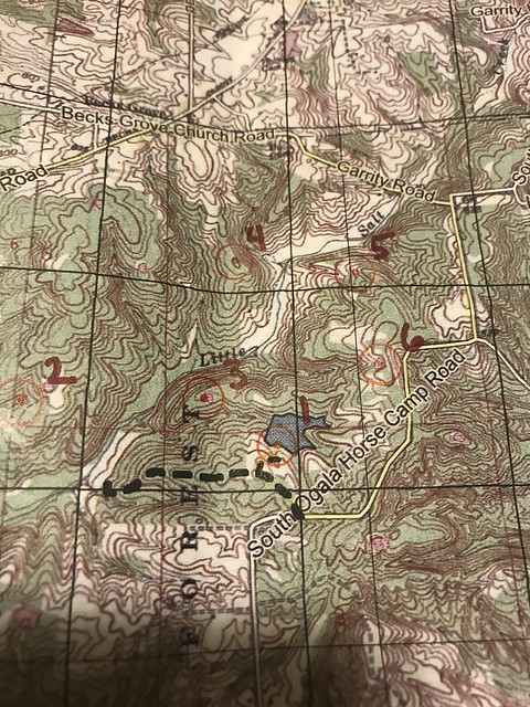
Finally we decided to try to find our way back to CP2 and reset, running into my friends Jeff and Rusty on the way. They were coming from 3 on their way to 2. Which, if you have to get the points in order, is cheating...and they aren't cheaters. "Um, don't you have to go in order?" we asked, but I was already pulling out the race instructions.
 |
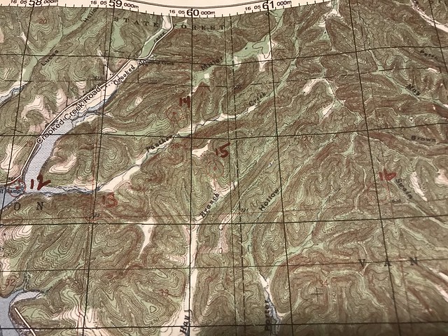
| Shit. |
Looking at the picture of the map, my *guess* is that it’s the printing on the map that threw me off. I use a thumb compass and usually fold my map, so I don’t look at much more than the area between where I am and where I’m trying to get. Also, I’m used to the text on a map lining up with North. If you look at the picture, the word “FOREST” is the main printing between CP2 & CP3, and it’s not lined with North. It’s lined up with West, 90* off what I would expect. I’m not sure that explains why I kept trying to go South when I wanted to go East, but my head is spinning, so I’m going to quit thinking about it.
 |
| The first trek |
 |
| What happens when your bearing is 90* off...twice. |
Once we were headed in the correct direction, we were at CP3 quickly, but we'd lost a lot of time. The TA would be closing in two hours, and we weren't quite halfway into the trek. "I think we should think about which point it makes the most sense to drop if it comes to that," I suggested.
Mickey was frustrated with our error and not interested in talking about skipping points. One of my concerns about teaming up was our very different abilities and race philosophies. He's far stronger and faster than I am; he's more competitive, too, and was definitely not ready to concede the possibility that we could clear the course. I like to do the best I can, but I race for the fun of it and if I had a tagline it would probably be "you know we're not going to clear this course".
Anyway, I shut up about skipping points for the moment, and we had a clean approach to CP4. Then we overshot our attack point for CP5, covering the wrong spur twice in our search for the PVC checkpoint marker before following it all the way up to the road. With time getting short, we decided to pass on CP5 in order to collect the harder to miss 6 on the way back to our bikes. We might have had time to get 5 as well, but in the end we made it back to the TA with 15 minutes to spare, and given our shaky start that was no sure thing.
We'd shot ourselves in the foot with easily avoidable mistakes but still had plenty of race left, and a lot can happen in 18 hours. We punched CP1 and got back on the bike for the remainder of leg 1. Mickey did a good job of telling me about upcoming turns and things to watch for. We made good use of tow except on big downhills, where I was too nervous to stay attached. Of course, this then meant I didn't have the assist on subsequent uphills. It's something I need to work on.
We turned from the gravel onto singletrack and followed that through a super muddy section onto smoother trail and to our attack point for CP7, which was plotted off the trail down a spur. We dropped our bikes and started hiking. Though the CP appeared to be plotted on an old trail, we found no such thing, and my decision to take off my trekking pants for the bike leg immediately proved to be a poor one. Thorns shredded my legs as I chased behind Mickey, cursing the race director for his sadistic CP placement.
We got way further down the spur than we should have with no sign of the CP, so we retraced our steps, each taking a side of the spur and looking carefully for our point. Finding nothing (other than more scratches), we returned to the bikes and looked at the map. Was it possible we weren't at the right spot? We rode further up the trail with no luck, so we decided to go all the way back to the road and try again.
Luckily, we reached our initial attack point at the same time another team arrived there. They were very sure of their spot, which made it likely that we'd been in the right place all along, so we decided that 6 pairs of eyes were better than two. Mickey and I started ahead of the other team (me still in shorts because I'm a slow learner) and almost immediately hit a trail we hadn't seen before, following that directly to the CP. Looking at the maps after the race, it was clear that we'd originally walked down the wrong spur, a mistake I should have caught back at the bikes since I'd done the same thing in February at the Meramec O meet.
This
is when it finally sunk in that being accurate with your nav is far, far more
important than being fast.
The maps had an overlay directing us down the trail and back to the road we'd take to our next TA. So easy...just follow the trail*. We had several spots of confusion when we arrived at unmarked turns. Looking at the map now other trails and turns are evident, but during the race I at least was focused on just the overlay and didn't notice them. We ended up missing a turn and weren't entirely sure where we were when we finally popped out onto the road, but with a little guesswork, a really big hill, and one more missed turn we finally reached the TA.
Leg 2: Paddle ~ CP 9-12
Only 3 or 4 lonely canoes were left in the field, and the 4-person team we'd seen back at CP 7 needed two of them. While I've been in last or near-last place plenty of times, it's still a little demoralizing. The volunteer gave us the coordinates for the paddle leg and told us, "We're all out of PFDs. The race director knows that, so you have permission to do the paddle without them."
You know me; I'm a safety girl. I can swim, but I still wasn't too happy with this news. "So, uh, how deep is this water we're going to be paddling in?" I asked.
"Well," he replied, "If you're worried about it you should probably wait for a PFD."
Not
having to wear PFDs was great news. It
made the paddle so much more comfortable.
Instead, we plotted our points, immediately deciding to skip the ones that required a long paddle in the wrong direction. Paddling is not one of our strengths as a team, and with our shaky navigational start we wanted to maximize daylight for our trek from the take-out back to the bike drop. Decisions made and still unhappily (on my part) PFD'less, we said goodbye to the volunteer and dragged our canoe to the creek.
By "we dragged", I mean that Mickey dragged it and I followed with the maps. That was awesome. Less awesome was when we got the canoe into the creek, climbed in, and I tried handing him the maps. "What are you doing? I can't steer and nav! You're doing the paddle nav."
The good news is that we were much smoother with steering and I almost never thought tipping was imminent, very unlike the much colder paddle in our first AR together. The bad news is that I suck at navigating on flooded creeks. I couldn't paddle and look at the map and compass, and landmarks I was watching for, particularly places where the creek came really close to the road, were obscured by flooding. Well, except for the bridge we didn't realize was THE bridge we were looking for.
I
still contend there was something wrong with the canoe that we had at CW8 that
year. I’ve NEVER felt that tippy in a
canoe, and I’ve paddled with plenty of people that have no idea what they’re
doing in a boat.
The subsequent good news, though, is that we ended up much farther along the paddle than I'd thought we were. And we were very fortunate to hit the spot where the creek split while that four-person team we'd met up with earlier was still there to explain to me where we were. Otherwise we might still be on the creek. We ended up unintentionally missing CP9 as well as CPs 10 and 11 which we'd intended to skip, but in retrospect I think the smart race decision for us was to skip them all.
 |
| Also nice? When things accidentally work out for the best! |
That
was laughably bad. I’m sure everyone on
the ramp was asking themselves how we had made it that far. And the answer, on the paddle anyway, was dumb luck.
Leg 3: Trek ~ CP13-17
 |
| CP12 was our paddle take out |
Mickey nailed CP14, which was a great confidence boost after our rough morning. Regardless, we decided that we were better off moving forward towards 15 and 16 rather than backtracking. We ran into a male 2p team on the way to CP15. They were coming from the direction we'd intended after struggling in their search for the checkpoint, but we felt pretty confident in our approach and stuck with the plan. Once again, Mickey led us straight there. Yes!
These
two CPs were definitely the highlight of my day! Other than getting to spend the entire day within 100 feet of me, anyway.
The route from CP 15-16 wasn't obvious. A direct bearing would cross a roller coaster route of multiple steep descents and ascents. We ended up opting for my idea, which was to continue down the reentrant from our CP and, once at the bottom, follow the main reentrant to its end, climb out, and hopefully hop onto the trail along the subsequent ridgeline. In retrospect, I think a better plan would have been to climb back up from the CP15 reentrant and follow the ridgeline above it to the trail, but that wasn't the decision we made at the time.
 |
| Probably still on the trek up the creekbed 7:30 p.m. |
I
really felt like if we didn’t get at least most of the way out (or at least to
a point where we knew where we were) before the Sun went down, we were in
serious risk of having to spend the night in those woods. That would have definitely been suboptimal.
Our bearing led us up a crazy steep reentrant. Between sliding down the damp sides and crawling on my hands and feet, all I could do was laugh. We were both concerned about how long it would take us to cover this terrain in the growing darkness (for me, it was bringing back memories of being lost at night with Chuck in the middle of the Chequamegaon National Forest), but at the top we miraculously stumbled onto a trail that was heading in the correct general direction.
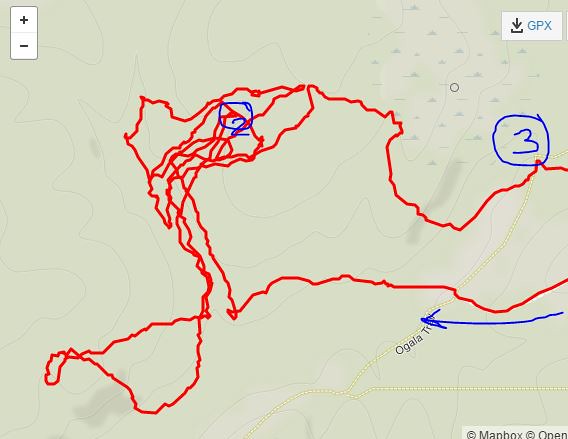
Looking at the map, I was pretty sure we'd ended up on the very trail we'd been looking for, but being unsure of exactly where we were I wasn't pushing to look for the CP. I really wanted to get to a known point before nightfall.
 |
| The solid red line is from my tracker, which died at the black & white circle. The red dotted line was our planned route. We came out of the reentrant early and then, instead of staying on the ridgetop until hitting the trail, dropped down into the next reentrant. We actually ended up exactly where we wanted to be, but by then weren't sure where we were or where we'd gone wrong and were more focused on getting back to the road before dark. |
That's a regular AR experience for me, so I shrugged my shoulders and followed along, but we quickly came to the end of the road. My heart sank a little -- wait, I thought we were found! -- as we retraced our steps and continued in the other direction. It turned out we were on an unmapped side road which soon intersected with what we thought was the correct road.
Fast-hiking down the road, we approached a house. "Wouldn't it be great if that was one of those mailboxes with the whole address?" I commented. My wishful thinking was rewarded when the other side of the mailbox confirmed that we were indeed on Blue Creek Road. Dark fell as we trekked back to the TA, and we were a little nervous about how long the trek was taking. Boy, it would be "a shame" if we got back to the TA took late and had to get a ride...I fantasized.
Mickey had a slightly different thought process; as we recognized our turn into the TA he told me, "I thought we were going to have to run to beat the cutoff." Run. Ha. He's a funny guy.
Though we'd been one of the last teams to reach this TA earlier in the day, the field was still littered with bikes on our return. That in itself doesn't mean a lot; we'd skipped several CPs during the paddle/trek, so the teams who hadn't arrived back yet likely had gone after the points we'd missed. However, we got back around 9:30, the TA was set to close at 10, and the race ended at midnight. The other teams were quickly running out of time.
Some people had already made this calculation: as we plotted our points for the last two hours of the race, the 4-person team we'd seen so much of earlier in the race drove up to pick up their bikes, having determined they couldn't make it back in time and called for a ride.
Leg 4: Bike,
There was a lot of race left after the TA for teams who'd moved through the course faster than we had; we were very limited by time. As I read off the coordinates for the next bike leg, Mickey pinpointed them on the map -- almost all in the opposite direction from the finish line -- and we quickly dismissed them.
Only two bike points, CP18 and CP25, were even under consideration, and we knew we wouldn't have time for any of the orienteering CPs. Mickey mapped out our route back to the finish, a miraculously flat ride, and guestimated the distance at around 30K. Given his strength on the bike and our use of the tow, we should make it back in time with no problem.
We looked again at the two bike points. CP18 was slightly out of our way and required riding up and over a godawful hill twice -- out and back. We'd already done this once earlier in the day, and I wasn't enthused about repeating the process. CP25 was considerably farther out of our way and forced us off of the lovely, flat route Mickey had planned for us. Mickey pushed for CP18. "Come on, we know where it is. You know we aren't getting any of those points back at camp."
That was convincing enough for me. The uphill was terrible (in both directions), but once we were finished with that it was smooth sailing. The roads were flat and largely paved, allowing us to keep a steady pace. We made a few quick stops to check the map, intent on avoiding any missed turns this late in the race, and reached camp after one final (and unwelcome) climb.
I use my fitbit as my race watch, and since I have to tap the face to see the display I have a hard time checking it on the bike, particularly when we're towing. As we rode into camp and passed the little lake where two special challenge CPs were obviously taking place, I considered whether we should stop for a quick time check. Noticing a racer swing far out over the water on some bungee-type of freefall apparatus, I thought Hell. No. and kept on pedaling.
How’d
that work out for you?
We flew down one last big downhill and up to the finish line, where the race clock showed 45 minutes left. We'd covered that last bike leg far faster than our conservative estimate. Good for us. And now we're finished. Yea team!
But wait...Mickey is saying things like "We still have 45 minutes left..." and "Let's just check out what they are..." and "Come on, these points could make the difference..." Rather than be dissuaded by my disinterest in riding back up the hill we just descended, he's offering to tow me up, which is all well and good but I still have to pedal my bike. I'm grumpy for the first time all race, muttering curses at my teammate's back as I struggle uphill.
At the top, I categorically refuse to have anything to do with the swing of death, so we stop at the little beach and ask about the challenge there. It's a riddle about a farmer and a chicken and a fox and a bag of grain. Once you solve it, you have to act it by paddling across the lake. Luckily Jacob loves riddles and I've heard this one a million times, and since these extra CPs are Mickey's idea I nominate him to be the one to do all the work while I first wait and then sit like a princess in the canoe.
We finish that challenge with 25 minutes still on the clock. The other CPs are too far away; the only remaining possibility is the freefall. I'm even less happy about this than the hill, but I get instructions from a volunteer who totally reminds me of my friend Emma and strap myself as tightly as possible into the provided harness. I tell the volunteers I only want to go the absolute minimum height required, which is halfway. It's every bit as terrifying as I'd anticipated and also, once I'm safely back on the ground, kind of fun to have done. Of course Mickey goes as high as possible, and of course the pictures taken in the dark don't turn out at all.
The
volunteers working the swing said you had the loudest scream of the night. That’s my teammate! Also, that swing was a trip. Because of the way the lights were angled, it
totally looked like you were going to swing back into the poles holding the
thing up when you swung back over land.
There's no more time left to go after any more CPs, so we ride back down the hill to the finish line for the last* time and hand in our passport. We did it! Only after we set our bikes to the side do I realize I'd left my pack back up by the lake. No way am I riding up that hill again, so I turn to my long-suffering teammate. "You're going to go get that for me, right?"
I
still think you left it on purpose so I’d have to ride up that damned hill
again.

When he returns, we make a beeline for the post-race meal and hear how everyone else's race went. By the time Brian announces the awards, around 1 a.m., many bikes are still at the TA we'd left around 10 p.m. In the end, something like 9 teams are transported from the course. We made our share of mistakes, but we made good decisions where they counted most and ended up being the first place 2-person co-ed team, the only team in our division to finish.
It definitely wasn't a result I anticipated given the problems we had, but it proves all over again that anything can happen in a long race. That was a lesson I re-learned this race -- keep racing until the end. The other big one for me was to pay better attention to details on the map. I tend to have tunnel vision and see where we're supposed to be, but there were all kinds of little trails that I missed because I was focused on the overlay.
I
really struggle to pick out the fine details on 1:25000 scale maps. My main lesson from this race is that clean
nav is more important than fast nav. I
have a couple of equipment modifications to do before my next long race, but my
body held up pretty well. Bring on No
Sleep 24 Hour!
Big thanks to Brian and the whole D.IN.O crew. They put on a quality event. Maps were good, directions were clear, coordinates were accurate, and boy was the terrain challenging. There were some hills that had me promising never to race in Brown County again, but now that it's over I would totally go back.
Footnotes:
* = not really


Comments
Post a Comment