Commentary by Chuck in green.
I hadn't realized my mojo had been missing until suddenly it was back. Chuck and I were on our way to the Fig and I was excited -- excited!! -- to go race.
I can't remember the last time I felt that way. No one is paying me to race, and no one is twisting my arm to sign up, but this year whatever stoke existed at registration time pretty much evaporated by race day, leaving traces of resignation and the unhappy suspicion that
maybe I'm too old for this.
That's stupid, of course. I'm definitely not too old for this as evidenced by all the older (and often
considerably older) people who kick my ass on a regular basis. So what has sucked the fun out of one of the real joys of my life? I don't think it's depression, though the last few months before I get a new IUD have typically been emotionally rocky ones for me (crazy hormones are the devil). I'm sure work stress hasn't helped, and the school years bookending the past summer have been among the three most difficult of my career. Those could be contributors, but I think there's more to it.
Can one overtrain if one barely trains? Maybe not, but my chronically deficient training may well be the problem. Without doing the work to back up the effort, I think maybe my registrations are writing checks that my body can only cash at great cost. Like someone who has to resort to those scammy check cashing places to pay the bills, I'm paying physical interest on these races long after they're over.
Or maybe Chuck was right and the difference was that, for the first time since
LBL in March, I wasn't racing solo.
Chuck: I was probably right, but as the oldest member of the team, you shouldn't be so quick to rule out the age factor.
Kate: Call me old one...more...time. Seriously, Chuck calling me old despite being 8 years older than me never fails to amuse (him).
***
Pre-race:
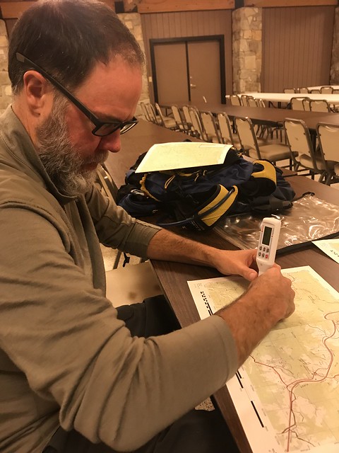
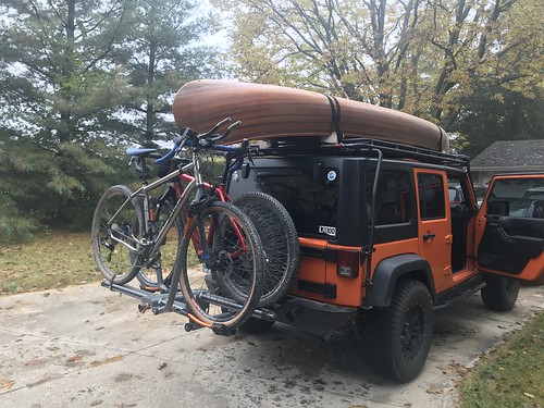 |
| Loaded for adventure! This was the first AR for Chuck's Cutthroat and my Fargo. |
Anyway, the 6-hour drive was long enough that both of us commented that it was a lot of driving for a 12-hour race and maybe next year we'd stay home. Arriving in the Red River Gorge area, though, we quickly remembered why the race is worth the trip. The area is absolutely incredible. Even the rain (
seriously, Mother Nature???) falling on us as we left my precious Salsa Fargo and Chuck's Cutthroat in the care of the bike drop wasn't enough to dampen (ha ha) our enthusiasm for the race.
We took our maps back to the hotel after the pre-race meeting, made quick work of plotting, and then began to strategize. The race was pretty straightforward: only TAs were mandatory, CPs could be punched in any order within the leg, and you couldn't come back to a section once you'd left it. The race was broken up into six parts: prologue, paddle, trek, bike, trek, bike.
Prologue: short run to Mill Creek Lake, site of TA1 and the paddle.
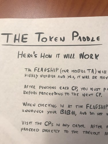
Paddle: 4 points on Mill Creek Lake. This lake is delightfully small, but 361 extended the paddle by adding a "flagship", a roving boat you had to return to and after punching each point.
"Embrace the chaos!" Dallas told us at the pre-race meeting, which sounded a lot like "
You're going to capsize in 30 degree water!" Unsurprisingly to anyone who knows me, I suggested skipping the paddle, but Chuck reminded me that we weren't going to see 4 CPs in such close proximity for the rest of the day.
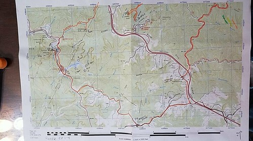 |
| This map covers the start, paddle, beginning of trek 1, a little of trek 2, and bike 2. |
Trek 1: About 10K of trails with 2 CP along the way to the bike drop.
Bike 1: 6 CP, two directly on the route between the two treks and four of which were spread around a huge loop. A mix of pavement, gravel, and a little singletrack. I think we estimated the whole bike leg to be about 50K.
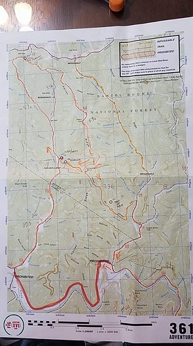 |
| All for bike 1 |
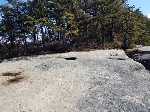
Trek 2: 5 CP, mostly close to the trail, that were pretty spread out. Even at our most optimistic we knew we'd be dropping at least one of these.
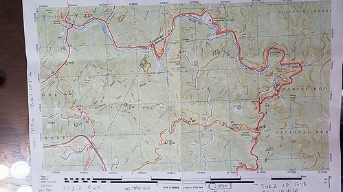 |
| End of bike 1, part of trek 2, and the start of bike 2. |
Bike 2: 2 CP along the road on the way back to the finish line. About 20K, looked to be primarily pavement.
The crux decision was what to do about that first bike leg. Dropping the four points along the big loop would save a ton of time, but it would leave us no options if we somehow cleared the second trek; we wouldn't be able to go back for any additional CPs...the only ones left would be the ones along the final bike back. Potential road conditions were another factor compounding the length of the loop, as we'd learned during our first trip to the Gorge.
In the end, doing the whole bike leg was a no-brainer for us. We were excited to be using our bikes in their first AR, biking is more of a strength for us than trekking, and riding muddy roads sounded infinitely more fun than hiking muddy trails. Lots of other teams, including our friends from BOR, made a different decision, so we were interested to see how it would play out.
***
Race day:
Our hotel was nice enough to put out its continental breakfast an hour early since the boat drop opened at 5:30, so we grabbed some oatmeal and a cold donut before rolling out. We got Chuck's canoe staged and were at race HQ super early, which gave us a chance to measure distances and estimate times for each leg. That's something we always do but had neglected the previous night. We're rusty! This was my first AR since February and Chuck's first since last November.
Chuck: We have to avoid these big gaps between ARs next year!
Prologue: run to Mill Creek Lake ~ 1.4 miles, ~15 min.
The race started right at 7. We ran downhill in the morning darkness and around the outside of the campground. If anyone was awake I'm sure it was quite a sight. It was a mostly downhill run, but I was excited to not feel like I might die of a heart attack at any moment. Usually running with a pack feels like death, but I felt pretty good.
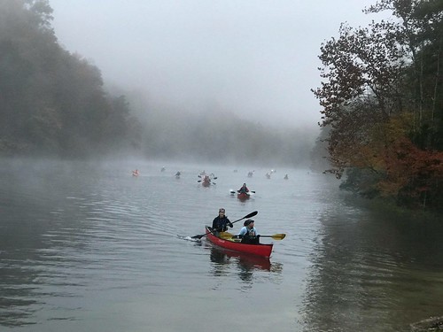
"Token paddle": 4 CP, ~2.9 miles, ~ 46 min.
We'd registered for the race at almost the last minute, by which point there were no canoes left to reserve. I'd offered up our beater aluminum canoe, but after we learned we'd be paddling on Mill Creek Lake Chuck had decided to bring his cedar strip canoe. It had drawn attention since
our very first gas stop, and the paddle was no exception to this. "Nice canoe!" "That's a beautiful canoe!" "Did you make that yourself?" The compliments and comments followed us around the lake.
But first we had to get onto the lake. Our early morning staging had given us a close spot, but we had a brief hitch when our bow glow stick refused to glow. Thankfully I had an extra, and after a minute or two we were in the water.
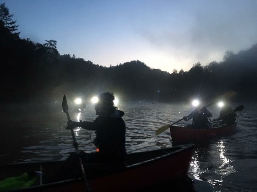 |
| Photo credit: 361 Adventures |
Chuck's canoe was super stable, and all of his MR340 training was still paying off because we flew through the paddle. As nervous as I'd been about the whole flagship thing, having to look for its strobe light and hunt it down actually added an element of fun to the paddle. And it was SO beautiful on the lake, first seeing all the lights moving around in the foggy dark, and then watching as the sun began to rise behind the surrounding hills. We made quick work of this leg, even ringing the flagship bell an extra time on our way out because I hadn't told them our number on our first pass by them and wanted to make sure we got credit for all of our mandatory trips to them.
Chuck: I can't believe you used the words "fun" and "paddle" in the same sentence! But it's true. I had a great time on this leg, too.
 |
| Photo credit: 361 Adventures |
Trek 1: TA1/2 (paddle) to TA3 (bike drop), 2 CP, ~6.5 miles, ~2:19
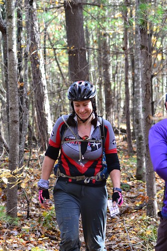
We ran (this again!) from the take-out down the highway to Whittleton Campground, at the end of which we picked up the Sheltowee Trace. Once we hit the trail we stuck with a fast hike. If we'd had any doubts about trail conditions, they were quickly cleared up. It was beautiful but slick, so we knew mud was going to be the word of the day.
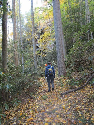 |
| Chuck on the trek. |
 |
| BOR took almost the same picture. |
Several teams and solos passed us during this leg. We had some beautiful views and no problem finding the CPs. At one point I mentioned thinking that a hillside seemed really familiar and Chuck kind of laughed at me. I was the one laughing a little later when we arrived at a picnic area we'd used as a TA back in
2015. I knew I'd been there before!
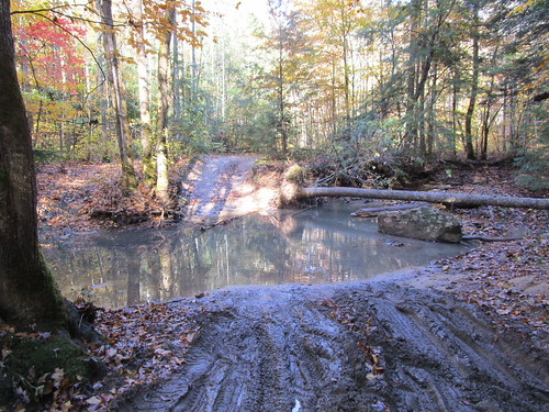
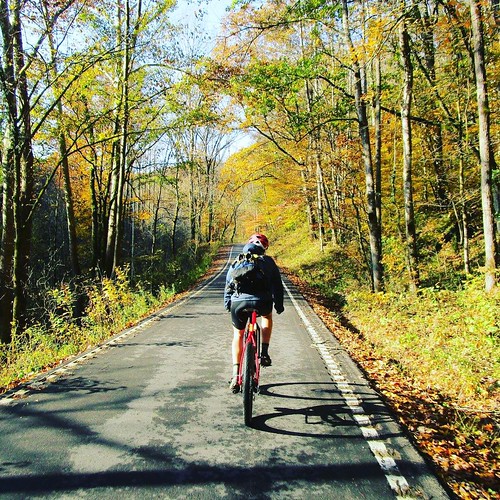
Bike 1: TA3 to TA4, 6 CP, ~35 mi, ~6 hours
The bike leg began with a long stretch of pavement, and we eventually turned onto a section of road that had originally been designated as prohibited because it was closed to traffic. It had been made race-legal at the last minute, after the race directors had convinced the powers that be that adventure racers on bikes could probably negotiate a collapsed road without too much drama.
As we learned on arriving at the spot, "collapsed road" sounds a lot more dramatic than the actual conditions. There was one area where a good-sized piece of road had fallen into the river below (or whatever was below), but there was still enough room for a car to pass safely. From there, we turned onto Spaas Creek Road. We'd expected this to be filled with puddles and bike-swallowing mud holes a la
2014...
 |
| One of the creek roads from 2014. |
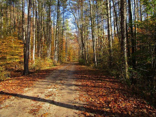
...but instead were treated to gloriously smooth gravel and beautiful views:
 |
"Is this heaven?"
"No, it's Kentucky." |
I know I thought it was pretty funny our friends had skipped the bike leg because they thought it would be super slow and here we were cruising along, making great time and thoroughly enjoying the day. Suckers!
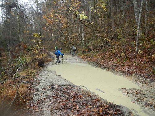
And shortly before arriving at CP10 we crossed the county line, and everything changed.
 |
| 9:06 (or maybe 10:06. I doubt my camera was set on Eastern time.) |
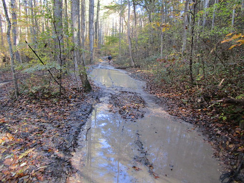
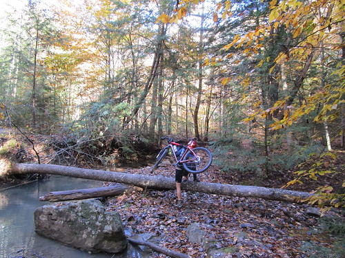
We dropped our bikes at the beginning of the hike-a-bike up to CP10 (so I guess it was just a hike up), then returned to continue dodging puddles. At first I'd try to ride along the edge, but eventually I found that I was generally fine just riding straight through the middle.
 |
| 9:10 |
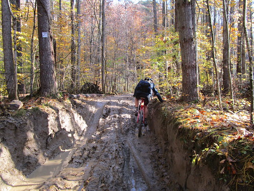
"Generally" is the key word there. At one point I got about halfway through a puddle before my front wheel began to sink into the mud, and suddenly I was nearly thigh deep in some really stinky mud. Luckily Chuck was following me at that point and got to watch the trainwreck unfold.
Chuck: I laughed so hard when your front wheel all but disappeared into the muck.
 |
| 9:25 |
It was slow going, but it was super fun. I think the 2014 edition of the Fig was the first time I'd ridden roads like these, and now after our trips to the Red River Gorge and the Shawnee National Forest, puddle-filled jeep roads seem normal.
Eventually the road started to climb, giving us hope that we'd leave the mud behind and start making better time, but that didn't really happen until we were almost all the way to CP9. I rode more than I expected to, but eventually I resorted to pushing my bike up a muddy hill, mentioning to Chuck how glad I was that we'd chosen this direction to ride this loop because there was little chance I'd have been brave enough to ride down the slip'n'slide.
Around CP9 we turned onto Hatton Ridge Rd, leaving behind the mud and flying down rideable (what?) gravel again. It was a swift ride to the turn to CP10. Again we opted to drop our bikes and hike, though at nearly a kilometer to the CP that may have been the wrong choice. Still, the trail was pretty soft and riding may have been slow anyway.
 |
Everybody hikes in a bike helmet, right? Safety first!
Photo credit: 361 Adventures |
The view at CP10 (overlook) was amazing, but I was super thankful to have a braver teammate who was willing to go punch our passport so I could continue my pattern of avoiding things that scare me (in this case, heights).
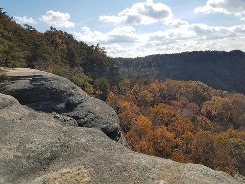 |
| The picture really doesn't give credit to how beautiful it was. |
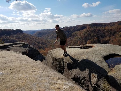 |
| Chuck on the return trip, his slip a few seconds earlier having justified all of my fears. |
 |
| "I'll just wait over here where it's safe and not watch you near the edge." |
Following the overlook, we just had one CP left to close out the big loop. We turned onto the Powder Mill trail and almost immediately began walking our bikes down the steep hill. Then we lifted them down a couple big drops. Then we pushed them some more. Eventually the trail leveled out and we got to do some riding.
With the amount of pushing we had to do and no bike computer, it was hard to judge how far we'd gone towards the CP, so we stopped a few times to check the map before arriving at the right spot. After punching CP7, we had a little more trail to go and then were back on the road again, making great time to knock out the final two CPs of the bike leg.
My Fargo has a silly low granny gear, one that's mostly for bikepacking, but I was super thankful for it on the final climb to TA4. It was steep and long, the kind of climb that will break your heart when it appears to be leveling out, then you come around a curve and see more hill looming.
Chuck: That may be the biggest hill I have ever ridden up. I seriously can't remember a taller one.
Trek 2: 6 1 CP, ~2 mi., ~1 hr.
We arrived at the TA a little after 4:00, which left us just under 1:30 until our self-imposed cutoff to be back on the bikes and heading towards the finish line. My only other AR this year was a 24 hour, so it was startling to have so little time left in our race. We realized that was probably only had time to get the closest trekking point, which was a bummer.
We crossed paths with several teams we knew on the trek, all of our friends leaving as we were just arriving. It seemed to take forever to get to the CP, where we then had to wade through thick mud to punch the passport. My feet were a little sore from being wet most of the day, and however the race standings played out we were both happy to have opted to bike through mud instead of trekking through it.
Bike 2: 2 CP, ~14 mi, ~1 hr.
This was a mix of gravel and pavement, and Chuck navigated us back with no problems (except for the time lost when I had to dig the passport out of the pocket of the pants I'd buried in my pack). There was a little more traffic than I enjoy riding in, which gave us a little extra incentive to push the pace. We started to see some familiar places from previous races, including one screaming downhill that showed me that despite my progress on downhills Chuck is still far, far braver and faster than I am.
Chuck: That downhill was SO much fun. Really wish we had a Garmin to record how fast we went.
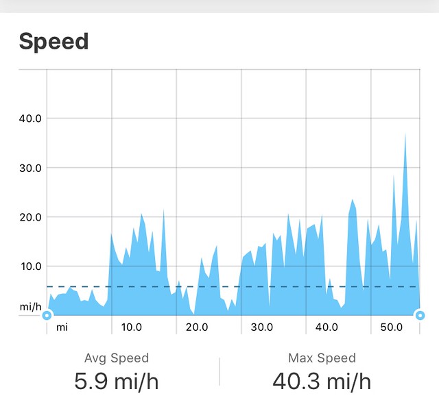 |
| Ask and you shall receive. This is how fast I was going. Chuck was faster than me. |
We turned into the campground, flew downhill and around the outside, and then had the final climb to the finish line. I'd remembered it as easier than it looked, which was definitely not the case. I kept expecting other teams to fly by us as I crept uphill, but we made it to the top with no one passing us, and turned in our passport with 45 minutes to spare.
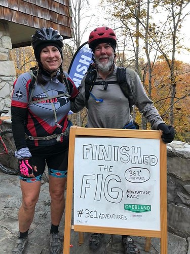 |
| I look so weird in this picture. |
45 minutes wasn't enough time to get another trekking point, unless maybe we'd have been able to run both ways. Of course, if we were going to run that trekking leg, we could have run the earlier one too and had more time to spare. Like usual, the biggest way we could improve is just to be faster, especially on foot. That said, it would be hard to improve our race experience. We had an awesome time and were both super happy with our race. If nothing else, we definitely topped the fun podium.


Comments
Post a Comment