April 6-7, 2019
The beacon that keeps drawing me back to the Shawnee National Forest got an assist from Mickey, who'd just bought himself a dynamo hub and light and was looking for a long ride to sweeten the 2-hour drive to pick them up. We thought about riding the Dirty South Roubaix route, eventually deciding to bikepack it over two days, giving Mickey his first bikepacking trip and me some much-needed training/practice.
He left the route to me with the caveat that he preferred something more rideable than the hike-a-bike extravaganzas I usually end up planning. We were working with an existing route, so I just had to figure out a way around a road closure and decide on a camping spot.
The plan: early departure from STL, a quick stop at Cyclewerx as soon as they opened to pick up the new wheel. Then we'd cross the river to Trail of Tears State Forest, where we'd leave the car and take the DSR route to Alto Pass. After a quick resupply at the market there, we'd follow a largely rideable stretch of the River to river Trail to Cedar Lake and camp at the great site Chuck and I had seen on our last trip there. The next day we'd return to Alto Pass via some new singletrack, rejoining the race route after a stop at Duty's Market for biscuits and gravy. I'd even done my due diligence, calling the State Forest office to check on overnight parking and attempting to make sure none of our route was affected by flooding.
The reality:
Day 1: For once, things went just as planned (well, except for our third person having to drop out that morning, me getting almost no sleep the night before, and Mickey being sick). We reached Cyclewerx before they opened. After getting the wheel and catching up briefly with John and Aaron, we got second breakfast at Sand's Pancake House and then crossed into Illinois. Next stop: Trail of Tears.
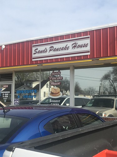 |
| So good we ate there twice. |
Google maps was not our friend, directing us onto a non-existent road. With no cell signal, we muddled our way there mostly through the route map I'd downloaded on the drive. Not the smoothest start to our adventure.
Finally at the start, we loaded up the bikes, changed clothes, and took off in absolutely perfect weather. After the winter we've had, riding in shorts and short sleeves and being comfortable felt amazing.
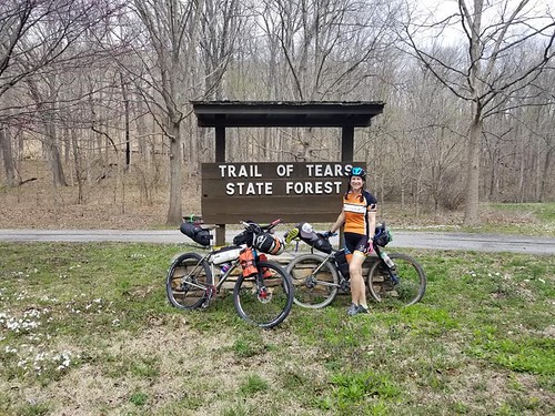 |
| Ready to go! |
The route starts with several miles of levee road, the latter part of which I'd been mildly dreading after finding it unpleasantly chunky the previous month. I should have appreciated it then, because this time around it was all torn up with a narrow, semi-rideable line along the side. It's a pretty area, but all I saw for those miles was the ground in front of me.
At the far end of the levee I breathed a sigh of relief which became a groan as I turned onto Old Cape Road and saw the flood water covering our route. We coasted up to the edge of the water. You could see the road re-emerge about a quarter of a mile in front of us. Neither of us wanted to retrace our ride on the levee, and I wanted to avoid extra miles to be sure of arriving at camp in daylight this time.
The first short flooded stretch was only a few inches of water over the road, but after a few more feet of dry pavement the water got deeper. Mickey looked back at me, and I shrugged, "I guess it's ok as long as it isn't over our knees." He hoisted his bike and started walking. Before long the water had covered my (taller) guinea pig's knees.
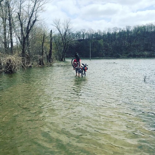 |
| Adventure! |
While high, the water was still, so we kept going, laughing about how stupid this was and (for me) struggling a little under the weight of the loaded bike. The peak depth ended up at about mid-thigh on me before becoming progressively shallower until we finally hit dry road again. Torn up roads and flooding: within 10 miles this trip was already providing adventure.
The flooding was at the southernmost point on our route. From there we looped back up to the state forest, riding a pretty gravel road through the campground but otherwise an awful lot of pavement. I didn't mind that other than feeling guilty that it was supposed to be a gravel ride; I guess I never noticed how much of it was paved when I was there in March.
 |
| Trail of Tears SF campground loop |
Mickey stopped to take a picture at a turn and I rode ahead. Some dogs from a nearby house ran into the road. I slowed for the two bigger ones in front of me and a third snuck up and bit my leg. I've been chased by a lot of dogs, but this was the first time I've been caught.
 |
| Adventure? |
Thankfully it was just one quick bite; the homeowner was home, very apologetic, offered to take me for medical care, and cleaned up my leg. Most importantly, the dog was current on its shots. Things definitely could have been worse. That said, it also hurt a lot more than I expected a couple of holes in a leg to hurt.
We turned off of the familiar part of our route not long after the encounter with my furry assailant. Route 127 into Alto Pass was closed, and the Dirty South race bypassed this via private property. My solution was to swing east through the town of Cobden before climbing Skyline Drive and following the scenic ridgeline road into Alto Pass.
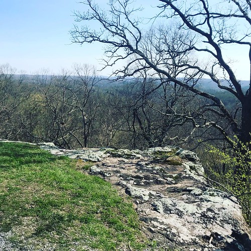 |
| Overlook in Alto Pass |
Once in town, we filled up our water and I restocked my ride food while Mickey grabbed a sandwich and started cold-soaking his dinner. While paying, I noticed a sign for biscuits and gravy, which solidified my breakfast plans for the next day.
A mile outside of town we made the turn onto a very different River to River Trail than Chuck and I had encountered last September. Instead of the forest of head-high fall weeds, Mickey and I met with a mowed field and a thru-hiker making his way west. We chatted with him for a bit, learning the unwelcome news that both campsites by Cedar Lake were already occupied, and then set off on the trail.
 |
| With Chuck back in September |
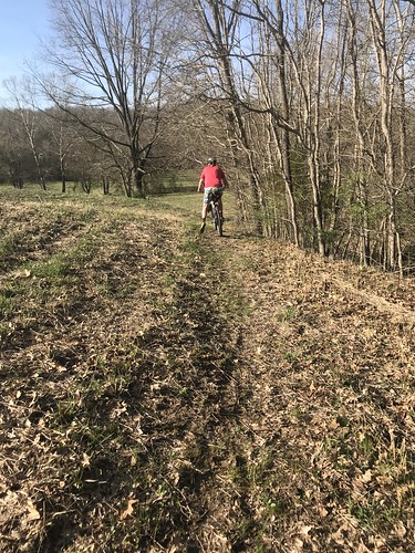 |
| Much better in the spring! |
Having struggled there before, I have to admit I was entertained by watching Mickey twice miss marked turns in the field. Even with the brush cleared it wasn't super obvious where to go unless you already knew, which made me feel much better about
how much Chuck and I struggled to find the trail last fall. The trail in the woods started out rideable but quickly became less so. Between this and the the largely paved previous section, I began to realize that my memory of things I've ridden is vague at best and to worry that Mickey was going to be annoyed about the amount of hike-a-bike.
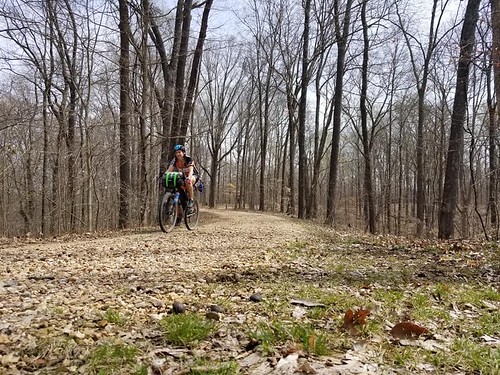
 |
| River to River Trail |
Soon, however, the trail improved. I began to recognize places Chuck and I had ridden back in September. It's much prettier in the daylight. My River to River Trail map had a campsite marked somewhere off the trail. I stopped early to investigate a (possible) trail that I thought might lead to the site, only to hike a ways for nothing. Back on the trail I found Mickey changing a flat right near the correct spur. Evening was closing in, so he sent me ahead to look for a campsite.
After hiking back and forth along the spur, I'd seen a great view of both Little Cedar Lake and the main lake but hadn't found a good camping spot, so he suggested I ride ahead to the lake and see whether the hiker was right about the occupied sites while he dealt with his still leaking tire. I did so, encountering a couple mountain biking in the opposite direction, and when I reached our intended site it was full of a big group doing a section hike. After three other trips to the R2R without seeing another soul on the trail, it was a little surreal (and inconvenient) to encounter so many this time.
Some fishermen had left coolers at the site across the spillway, but on my way back towards Mickey I passed them and learned that they were heading home. By this time I was starting to get nervous about getting camp set up before dark, so I was really happy to run into Mickey, who had finished dealing with his flat and ridden my way.
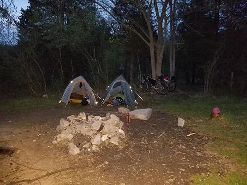
We gingerly crossed the slippery spillway and set up in a campsite with a great lake view. This was my first time using (or even opening) my new lightweight bikepacking tent, and set-up didn't go smoothly. Thankfully Mickey has the same tent and
had practiced setting it up. Even with his tutoring, though, I have a lot of room for improvement.
 |
| *Big Agnes ad* |
As they left, the fishermen warned us we were in for a wet night. We sat on rocks in front of the fire-less fire pit to eat dinner, then both of us were in our tents by 8:30. Him being sick and me running on little sleep and still bleeding from my dog bite, we weren't exactly a party crew.
I'd brought the sleeping bag liner I plan to use for Arkansas High Country so I could test out how it was to sleep in it and if it would be warm enough if the temperatures dip. I also brought my emergency bivvy to use with the liner if I got cold. Because I wasn't sure about how that would go, I also brought my 32* sleeping bag just in case. I started out the evening comfortably in the liner, and when I cooled off started to unpack the bivvy. Realizing what a pain it would be to try to repack that thing, I just opted for comfort and climbed into my sleeping bag.
Day 2:
 |
| Morning vibes |
I'd been nervous about the stormy forecast, but we didn't get more than a light rain overnight and woke to a cool, dry morning. I cooked my oatmeal as I started packing up, taking a few minutes to savor breakfast by the lake before loading my bike.
 |
| The spillway between the lakes |
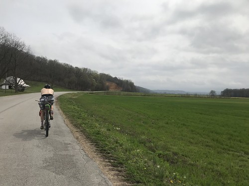
We picked our way back across the spillway in camp shoes to avoid soaking our bike shoes again, then rode past our neighbors in search of our return route. I'd just traced the approximate location of this new-to-me section of singletrack onto Ride With GPS. We never did find our turn, but the forest road we took dumped us onto the route anyway, cutting off a few miles from our day.
 |
| Seems like every morning starts with a climb. |
We arrived in Alto Pass, happily anticipating biscuits and gravy at Duty's Market, but were greeted by a closed sign. The hours, which I'd failed to check the previous day, started at noon on Sundays. Though we had enough food and water was available at the nearby park, it was a disappointment.
Leaving town our view of Bald Knob Cross on a neighboring hill was obscured by fog, but we were headed for a closer view. We turned onto an out and back to the cross; a fun, fast descent followed by lots of climbing and three miles later we arrived at the parking lot to see basically nothing. I had to laugh. Even 100 feet away the cross disappeared into the fog.
 |
| We rode up here for this? |
 |
| Better view close up. |
The fog burned off over the next 20 miles; by the time we started climbing Pine Hills Rd the sun was out in earnest and I was cooking in my cool weather clothes. I managed the climb without walking, something I hadn't anticipated after barely making it on an unloaded bike the previous month, and we stopped at the top to shed some layers before cruising back to the finish at Trail of Tears.
 |
| The turn onto Pine Hills Road |
 |
| The last few miles. |
What a great way to spend a weekend.
Details:
Nagivation: Garmin 520, Ride with GPS route also downloaded to phone for offline use because it's easier/clearer to zoom in on the phone than the Garmin.
Front roll: clothes (sweatshirt, capris, underwear,
knee warmers, base layer, rain jacket, extra socks), sleeping bag liner,
emergency bivvy, hat.
Attached to front roll with two large Voile straps: Big Agnes Fly Creek UL2 bikepacking tent
Feed bag: snacks
Seat bag: sleeping pad, sleeping bag, pillow, jetboil
Attached to seat bag with one small Voile strap: camp shoes
Frame bag: water,
collapsible bowl and spork, oatmeal, mountain house meal, tube, multi tool, $$, tire levers, charging cables, external battery,
inflatable cushion, hot chocolate mix, snacks. (Strikethrough items were things I didn't use.)
Lessons: time to buy some dog spray and be more prepared to kick at dogs if necessary, practice setting up your new tent before you're there, I have a bad memory for percentage of gravel/road and HAB, check store hours for places you're counting on, do a little more research on singletrack routes when you're including them.


Good stuff, thanks for sharing!
ReplyDelete