Arkansas High Country, day 3: back to school
June 10, 2019 Shady Rest cabins to informal campsite in the Petit Jean Mountains
91.1 miles - 7,315 ft elevation gain - 10:43 moving time/15:05 elapsed time
Day three was uncharted territory for me. Unless you count the supported Katy Trail rides I did in 2009 and 2010, I've only done back to back long rides two days in a row.
Since my Team Noah kit was still damp from its trip through the washing machine I decided to switch to the other kit I'd brought, but as soon as I started stuffing things into the jersey pockets I realized it wasn't going to work for me. The pockets were much smaller and harder to access, so I switched back to my original kit and repacked the dead weight extra one I'd brought. That was another preparation fail; I'd worn it on a day ride to make sure it was comfortable for all-day riding but failed to think through the storage capacity issue.
I left the cabin the next morning at 6:25 a.m., a couple hours after Mikey, a consistently early riser, and a little bit before Alex. Within 4 minutes I'd missed my first turn, but my Garmin alerted me and I made a quick about-face. A mile later I passed the other informal campsite on the map, this one right off the road, easily visible, and a great camping alternative. That said, it certainly didn't have any pulled pork sandwiches, so my $20 share of the cabin was money well spent.
I felt completely different than the previous morning, strong and happy. The temps were great, the scenery was beautiful, and thanks to my terrible start to day 2 I was able to really appreciate how good I felt.
Morning facebook post: "Day 3: you’re up,David Beattie and Robert A. Johnson! You guys, I feel 100% better today. Ride satisfaction is off the charts. What a gorgeous place to ride. This is my favorite day so far. Definitely my favorite morning."
Of course, the road conditions varied, but once again I recognized the similarity to Shawnee and Mark Twain roads and smiled in recognition. The "miles to end" (of the South loop) readout on my Garmin dropped to 199, and that felt like another reason to celebrate. The number had been 417 when I started.
My proximity to Hatfield (and second breakfast) was signaled by a turn onto paved roads. Reaching towns was always a mixed blessing. On one hand, there were services or, if not, at least houses where you could beg for water if it came to that; often, there was the sweet relief of pavement. On learning the race was 50% pavement, Mickey had winced at the idea of riding 500 miles of paved roads, but I felt differently. While I prefer gravel or singletrack, I've never hit a paved section during a long race and felt anything but thankfulness.
91.1 miles - 7,315 ft elevation gain - 10:43 moving time/15:05 elapsed time
Day three was uncharted territory for me. Unless you count the supported Katy Trail rides I did in 2009 and 2010, I've only done back to back long rides two days in a row.
Since my Team Noah kit was still damp from its trip through the washing machine I decided to switch to the other kit I'd brought, but as soon as I started stuffing things into the jersey pockets I realized it wasn't going to work for me. The pockets were much smaller and harder to access, so I switched back to my original kit and repacked the dead weight extra one I'd brought. That was another preparation fail; I'd worn it on a day ride to make sure it was comfortable for all-day riding but failed to think through the storage capacity issue.
I left the cabin the next morning at 6:25 a.m., a couple hours after Mikey, a consistently early riser, and a little bit before Alex. Within 4 minutes I'd missed my first turn, but my Garmin alerted me and I made a quick about-face. A mile later I passed the other informal campsite on the map, this one right off the road, easily visible, and a great camping alternative. That said, it certainly didn't have any pulled pork sandwiches, so my $20 share of the cabin was money well spent.
 |
| 6:45 a.m. |
 |
| 7:36 a.m. |
 |
| 8:01 a.m. I assumed the tire track was Mikey's, and it felt a little like riding with someone else. |
 |
| Also 8:01. |
But towns also meant dogs, and rural dogs rarely are constrained by leashes or fences. Wearing a scar from an April dog bite, I came to ARHC more worried about dogs than getting lost or camping alone, and they proved to be my biggest stressor of the race. I'd had to jump off my bike on day 1 to keep it between myself and a particularly unfriendly dog in Thornburg, and as I neared Hatfield I found myself sprinting away from two chasers. Luckily they'd appeared on a slightly downhill section, so I had no trouble escaping.
I made a beeline for the cafe on the corner and ordered what felt like half the menu for what ended up being a surprisingly low cost, catching up on the world during the short wait for my food. Alex arrived just as I was wrapping up the sausage patty and biscuit I'd been able to finish.
Before leaving town, I refilled my water at the nearby convenience store. With the benefit of hindsight, I now realize that this was the best of very limited on-route store options through the 130 miles to Waveland, but at the time I was planning 25 miles to the restaurant at Queen Wilhelmina and then restocking again at the Rich Mountain convenience store a mile later. If you're thinking Kate, it seems like that's a lot of time wasted with multiple stops...and what about Lesson 2, you're right, but at the time I was still learning and only picked up a couple of small items in the store (which, for future reference on days when My Kitchen Table is closed, also had a well-stocked little lunch counter).
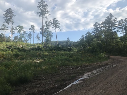
I didn't feel amazing the next 20 miles -- instead of rejuvenating me like the previous day's breakfast did, this one had me dragging a little -- but moved steadily along the road enjoying the scenery I passed. Around mile 33 for the day I turned onto CR-8, gasped in delight, and breathed "No way!" as a mama black bear and her cub crossed the pavement maybe 200 feet in front of me. I fumbled for my camera, but they were enclosed in brush on the other side before I got it out. I knew there were black bears in Arkansas, having read it during my pre-race research and sending a slightly panicked message to my friend Matt, who'd reassured me: "They're more afraid of you than you are of them," but I hadn't really expected to see them. I mean, there are supposed to be bears in Missouri, too, but despite all my time in the Mark Twain National Forest I've never spotted one.
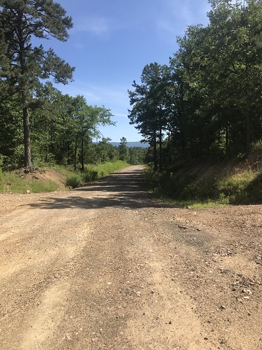
Knowing that we were headed into a state park I'd expected to be riding pavement, probably with lots of traffic to watch me have to walk my bike uphill, but I was in for a doubly happy surprise. The climb was gravel, and -- even better! -- I could ride it.
Thankfully for my low, low granny gear, I happily chugged along, catching up with Mikey, who was struggling with Achilles pain. There were a couple spots where the grade was steep enough that I had to walk a little bit, but I was thrilled to be able to ride as much as I did. Some rustling in the trees to my right caught my attention, and I looked up to see another mama bear, this time with two cubs, scrambling along the ridgeline above me.
This was another mandatory selfie stop, so I took a quick picture of my bike and headed off in search of the park restaurant.
Mikey pulled up as I was standing in dismay in front of a building with a "closed due to the weather" sign. Why would you close a restaurant due to weather? And what weather? It was beautiful out.
He gestured to the left, where the park lodge was. I was standing in front of the train ride building, maybe 10 feet from a big "Restaurant" sign with an arrow pointing to the lodge. Clearly my typical long ride brain fog was in full effect.
We met up with Alex for a leisurely meal in the lodge restaurant, all trying to figure out who the other loaded bike on the porch belonged to. It turned out that Jesse, one of the faster guys, had decided to drop there after experiencing some weird leg numbness the previous day. He was waiting at the lodge for his ride, came down to join us for a bit, and took our group picture at the overlook.
All good things come to an end, and the downhill trend did so abruptly as I approached the Petit Jean mountains. The grade rose gently for a mile before becoming more of a wall, rising 900 feet in less than two miles. I quickly had to get off my bike and push, and even that was a struggle at times. I'd walk 100 steps then take a break. Walk...well, 50 steps that time, and take a break. Every so often I'd peek at the elevation screen, only to see a steep diagonal line continuing off the screen. After 45 minutes of climbing I could finally see the end of the steepest part on my screen.
Looking back, I saw Mikey's orange shirt moving in my direction. Eventually he caught me, faster on foot uphill just like he usually was on the bike.
The sky was nearly dark when we finally reached a rideable point and I made the unsettling discovery that my dyno light wasn't working. It had worked great during paved points when I was using it to power my taillight, and it had flawlessly charged my external battery during the day, but now neither the headlight nor taillight were working. I tried pushing the cables further onto the connectors in case they'd jiggled loose...nothing.
 |
| 8:57 a.m. About to leave My Kitchen Table Cafe and Bakery in Hatfield. |
Before leaving town, I refilled my water at the nearby convenience store. With the benefit of hindsight, I now realize that this was the best of very limited on-route store options through the 130 miles to Waveland, but at the time I was planning 25 miles to the restaurant at Queen Wilhelmina and then restocking again at the Rich Mountain convenience store a mile later. If you're thinking Kate, it seems like that's a lot of time wasted with multiple stops...and what about Lesson 2, you're right, but at the time I was still learning and only picked up a couple of small items in the store (which, for future reference on days when My Kitchen Table is closed, also had a well-stocked little lunch counter).
 |
| 10 a.m. |
Knowing that we were headed into a state park I'd expected to be riding pavement, probably with lots of traffic to watch me have to walk my bike uphill, but I was in for a doubly happy surprise. The climb was gravel, and -- even better! -- I could ride it.
 |
| 11:24 a.m. I think this was the first time I (accidentally) discovered I could see the upcoming elevation profile on my Garmin. During bad times I spent a LOT of time looking ahead, sometimes in dismay and sometimes happy to finally see the top. |
Alex caught up with me while I was stopped, having again failed to get my phone out in time for a bear picture, and we watched as another bear ran across the road ahead of us. Not sure if it was the mama bear again we waited briefly to see if the cubs would follow, but after none emerged we proceeded cautiously ahead.
Mikey caught up with me again during a walk break and we rode together having the kind of conversation you do during a bike ride. Where you're from, what you do, your family, when you started riding bikes. I think that was the longest stretch of the whole race where I had company, but eventually he faded back a little and I continued on. 8 miles and 1600 feet after beginning the climb, I turned onto a blessedly flat ridgeline road with expansive views.
 |
| 12:17 p.m. Alex (in white) after our quick bear break. |
 |
| 1:02 p.m. Finally at the top after two hours of climbing! |
This was another mandatory selfie stop, so I took a quick picture of my bike and headed off in search of the park restaurant.
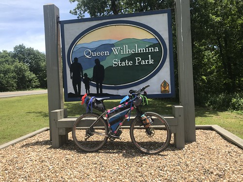 |
| 1:10 p.m. Queen Wilhelmina SP mandatory selfie |
Mikey pulled up as I was standing in dismay in front of a building with a "closed due to the weather" sign. Why would you close a restaurant due to weather? And what weather? It was beautiful out.
He gestured to the left, where the park lodge was. I was standing in front of the train ride building, maybe 10 feet from a big "Restaurant" sign with an arrow pointing to the lodge. Clearly my typical long ride brain fog was in full effect.
We met up with Alex for a leisurely meal in the lodge restaurant, all trying to figure out who the other loaded bike on the porch belonged to. It turned out that Jesse, one of the faster guys, had decided to drop there after experiencing some weird leg numbness the previous day. He was waiting at the lodge for his ride, came down to join us for a bit, and took our group picture at the overlook.
Facebook post: "You guys!! I saw five bears today! And two coyotes. And totally rode my bike up a mountain."

We all left at different times, and I ended up being the first one on the road, which treated me to a fantastic paved downhill, a little bit twisty but just straight enough to let me stay off my brakes and go fast enough to catch the Corvettes that had started down as I left the restaurant. Thinking there was a convenience store here, I looked to the left and didn't see it. I paused at the turn at the bottom to check my maps but when Alex rode past without stopping, I assumed the store was further along.
We continued effortlessly cruising the gentle downhill for another two miles. It wasn't until we reached our next turn at the sign for Eagleton that I stopped to look at my map. The store I'd remembered was, indeed, back at the bottom of Queen Wilhelmina, and I'd been counting on it to fill my water and restock my supplies. By this time Alex was too far ahead to hear me call, so I turned around and retraced my route, now a gentle uphill back to the store. Riding extra miles was the last thing I wanted to do, but the store was the last on-route opportunity for resupply for the next 100 miles.
I arrived back where I'd originally paused, and there it was. I'd actually seen the building but, expecting a convenience store in the vein of a Casey's or a Quik Trip, hadn't recognized the old wooden building as my destination. Once inside, my incorrect expectations continued. For all of my training rides, I used food that can be (or has been) bought at gas stations. I've gotten pretty good at fueling long efforts on that type of fare, but C-store choices around home are pretty varied. This particular store had a lot of stuff, but very little of it was packaged food. They also had a lunch counter/restaurant, but having just eaten at the lodge I wasn't interested in (or maybe just didn't think about) having anything prepared for me. Not only had I failed to heed lesson 2, but I was adding more to the curriculum:
Lesson 8: Check your map when you first have a question, not two or more miles down the road.
Lesson 9: Don't assume that because someone else rides ahead without stopping that you should, too.
Lesson 10: Rural Arkansas convenience stores don't necessarily look like what you're expecting.
Lesson 11: If the food you're expecting isn't there, take advantage of the options you DO have.
"Are you doing the long route or the short route?" the man behind the counter asked me.
"What's the long route?"
"70 miles," he answered.
"I'm doing the 1,000 mile route."
While they weren't familiar with ARHC, the owner told me that they have a lot of cyclists come by on training rides. He had a lot to tell me about that and was super welcoming, mentioning outdoor showers and water available. He had me sign his guest book, and then when I went outside to load up my few purchases, he followed me out with a bag of Korean BBQ pork jerky and handed it to me.
Waving goodbye to my new friends, I rerode the now familiar road back to Eagleton and finally made the turn onto a fresh section of the course. I'd made more dumb mistakes, but at least this time I'd made the good decision to ride back to the store I'd missed. If only I'd taken better advantage of it.
The route continued with a downhill trend for the next 30 miles, passing through lots of beautiful forest and a few small towns with no services. At some point I caught up with Mikey, who'd passed me while I was stopped at the store. We rode together for a bit, but his Achilles woes were making it hard for him and eventually I was on my own again.

We continued effortlessly cruising the gentle downhill for another two miles. It wasn't until we reached our next turn at the sign for Eagleton that I stopped to look at my map. The store I'd remembered was, indeed, back at the bottom of Queen Wilhelmina, and I'd been counting on it to fill my water and restock my supplies. By this time Alex was too far ahead to hear me call, so I turned around and retraced my route, now a gentle uphill back to the store. Riding extra miles was the last thing I wanted to do, but the store was the last on-route opportunity for resupply for the next 100 miles.
I arrived back where I'd originally paused, and there it was. I'd actually seen the building but, expecting a convenience store in the vein of a Casey's or a Quik Trip, hadn't recognized the old wooden building as my destination. Once inside, my incorrect expectations continued. For all of my training rides, I used food that can be (or has been) bought at gas stations. I've gotten pretty good at fueling long efforts on that type of fare, but C-store choices around home are pretty varied. This particular store had a lot of stuff, but very little of it was packaged food. They also had a lunch counter/restaurant, but having just eaten at the lodge I wasn't interested in (or maybe just didn't think about) having anything prepared for me. Not only had I failed to heed lesson 2, but I was adding more to the curriculum:
Lesson 8: Check your map when you first have a question, not two or more miles down the road.
Lesson 9: Don't assume that because someone else rides ahead without stopping that you should, too.
Lesson 10: Rural Arkansas convenience stores don't necessarily look like what you're expecting.
Lesson 11: If the food you're expecting isn't there, take advantage of the options you DO have.
"Are you doing the long route or the short route?" the man behind the counter asked me.
"What's the long route?"
"70 miles," he answered.
"I'm doing the 1,000 mile route."
While they weren't familiar with ARHC, the owner told me that they have a lot of cyclists come by on training rides. He had a lot to tell me about that and was super welcoming, mentioning outdoor showers and water available. He had me sign his guest book, and then when I went outside to load up my few purchases, he followed me out with a bag of Korean BBQ pork jerky and handed it to me.
Waving goodbye to my new friends, I rerode the now familiar road back to Eagleton and finally made the turn onto a fresh section of the course. I'd made more dumb mistakes, but at least this time I'd made the good decision to ride back to the store I'd missed. If only I'd taken better advantage of it.
 |
| 4:15 p.m., around mile 61 |
I wasn't sure how far ahead Alex was. There were some boys shooting at fish from a bridge in Bates and I asked if they'd seen another rider. They hadn't, but they'd only been there for a few minutes. When I got a cell signal, I checked Trackleaders. He was way further ahead of me than just the four extra miles I'd ridden to and from the store. We'd all talked a little about where we planned to camp for the night, but unless he stopped soon it was clear that our little group of three wasn't going to be sticking together this evening.
 |
| 7:35 p.m. Strip Pit Rd, mile 85, elevation 707 feet I ended up camping at the top of the mountains in that picture |
All good things come to an end, and the downhill trend did so abruptly as I approached the Petit Jean mountains. The grade rose gently for a mile before becoming more of a wall, rising 900 feet in less than two miles. I quickly had to get off my bike and push, and even that was a struggle at times. I'd walk 100 steps then take a break. Walk...well, 50 steps that time, and take a break. Every so often I'd peek at the elevation screen, only to see a steep diagonal line continuing off the screen. After 45 minutes of climbing I could finally see the end of the steepest part on my screen.
 |
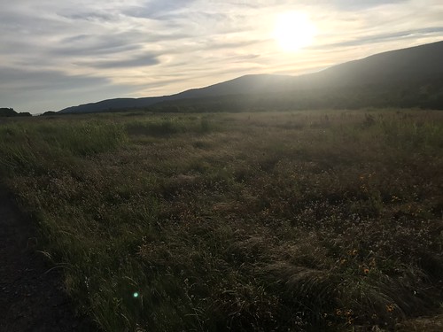
| 8:35 p.m., mile 88 |
 |
| 8:37 p.m., looking into Oklahoma, though I hadn't realized that I'd been there at a couple of short points earlier in the day. |
I'd brought a headlamp, but since I had such a good bike light I had only packed my small headlamp for use around camp. It definitely didn't do the trick lighting up the road, leaving me crawling along at a snail's pace. Though I'd hoped to ride further that evening I figured that my time would be better spent getting some sleep and then making better time when I could see.
I told Mikey as much. He pointed out a dispersed campsite nearby, but we hadn't yet hit my 90 mile goal for the day, so I wanted to continue on at least until I passed that. At mile 91.1 we found another site and called it a night. Mickey's hammock was set up in about a third of the time it took me to set up my tent. My need for comfort definitely cost me in weight and time, but given the number of spiders I could see around camp I was ok with that.
Camp chores finished, I ate the entire (delicious) bag of pork jerkey on my tent's front porch (not very bear aware), hung my sweat-soaked kit to dry, updated Facebook, and went to bed. My sleeping bag liner was comfortable at first, but I woke up chilly in the night and climbed into the emergency bivvy. Instantly cozy, I fell back asleep.
Evening facebook post: "Well,David Beattie and Robert A. Johnson each owe Team Noah Foundation $1.10. I’d planned to push on a bit further, but I’m having problems with my light this evening and wasn’t up to tackling these downhills in the dark.
Speaking of downhills, it’s crazy how fast a loaded bike will go downhill, especially when its rider is too tired to be scared. Speaking of uphills, on the other hand, it’s crazy how hard it was to push my bike up the last climb. All my morning mountain-ride glow was eclipsed by the struggle to get to the top tonight: 100 steps, then a break, 100 — nope — 50 steps, then a break. But now I’m in my tent partway up the next big hill and all in all it’s been a beautiful day. 91 miles down, just shy of 300 for the race (almost 1/3 of the way done!)"
Day 3 Strava file
Evening facebook post: "Well,David Beattie and Robert A. Johnson each owe Team Noah Foundation $1.10. I’d planned to push on a bit further, but I’m having problems with my light this evening and wasn’t up to tackling these downhills in the dark.
Speaking of downhills, it’s crazy how fast a loaded bike will go downhill, especially when its rider is too tired to be scared. Speaking of uphills, on the other hand, it’s crazy how hard it was to push my bike up the last climb. All my morning mountain-ride glow was eclipsed by the struggle to get to the top tonight: 100 steps, then a break, 100 — nope — 50 steps, then a break. But now I’m in my tent partway up the next big hill and all in all it’s been a beautiful day. 91 miles down, just shy of 300 for the race (almost 1/3 of the way done!)"
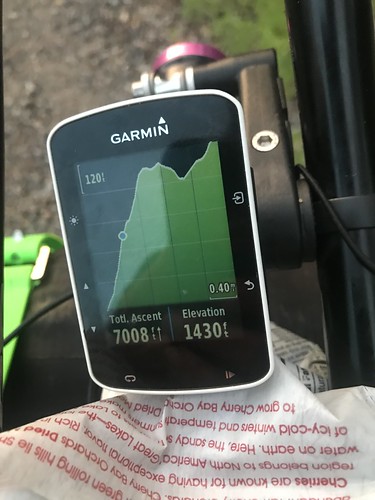
 |
| Here's an illustration of how deceiving an elevation profile can be. That climb in the middle is significantly higher, but it was a much easier grade and almost all rideable for me. The one at the end was much steeper. I doubt I could have ridden it all even if it hadn't come at the end of three long days of riding. |
Day 3 Strava file


This is great - I am really enjoying the trip! Thanks for putting it all down in such detail. x
ReplyDelete