Arkansas High Country, day 2: immediate feedback
Sunday, June 9, 2019: Crystal Springs to Shady Rest Cabins
84.6 miles - 6,399 ft. elevation gain - 13:57 elapsed time/9:57 moving time
I woke to my 5:00 alarm, happy to discover I hadn't been murdered in my sleep, and began the slow process of packing up the few things I had out of my bags: sleeping clothes, hygiene items, charging cords. I ate the other half of my Parkside PBJ and an apple then reluctantly put on my still-damp kit and rolled my bike into the cool morning air, finally beginning the day's ride at 6:21.

Morning Facebook post: "Day 2: this one’s for Claire and Stacey, but it’s probably going to be considerably shorter than yesterday because of limited sleeping options. Overall I feel pretty good except for my hands, which are already losing some dexterity. A little surprising given the amount of pavement yesterday and the large amount of walking I did on hills and (by the last 10 miles) anything resembling a hill."
As anyone who's my online friend knows, I'd decided to use my race as a fundraiser for the Team Noah Foundation. I shared that my hope was to ride 90+ miles a day and finish in about ten days. Friends (or strangers, I wasn't picky) could pick a day to pledge $1/mile for any miles I rode above the 90, and I in turn would donate $1/mile for any mileage under my target. I'd expected a couple of people to sign on, which was totally fine. It would give me some added motivation on pledged days and bring in a few dollars for the foundation but not be too much pressure.
Instead, within 24 hours all ten days were sponsored, most by multiple people. I'd been excited to pass mile 90 on the first day, securing around $100 in donations by the time I stopped, but the evening food and lodging challenges had made me realize that randomly riding as far as I could without putting a little more thought into where I was going to eat and sleep was a little further into the deep end than I was willing to swim just yet.
The beginning miles were largely flat and paved and shady. Early on, descending a smooth downhill, a Gatorade bottle flew out of the bottle cage on my fork. I retrieved the bottle and put in in a jersey pocked. You only got two strikes in this game, and the cage was out. My legs, on the other hand, had apparently benched themselves. In addition, my left shoulder and hip were bothering me and my hands were already numb enough that I was struggling to shift or do anything that required much dexterity.
I've done a lot of long rides and races to the point where a 150-mile day no longer sounds outrageous, but I have limited experience with back-to-back long rides and hadn't really understood their unforgiving nature. You can screw up your nutrition for a one-day race with limited consequences, but following a big day with another one will give you immediate feedback on your nutrition and recovery. My body was giving me an emphatic thumbs down.
Despite the easy surface and grade, I was painfully slow. Initial hopes that I just needed an extended warm-up after the previous day receded to eventual acceptance that this glacial pace was all my empty legs had to give. Rather than get upset, I focused on steady progress and kept moving forward.
Alex caught up with me about 90 minutes into the morning and we rode together for a while. I told him how my hands were getting numb, and he mentioned that he made an effort to keep his hands light on the handlebars. I'd been making an effort to change my hand position frequently and to not grip the bars tightly, but the idea of keeping my weight off of my hands finally clicked. The company was nice, but his easy pace still had me pushing harder than I wanted to, so eventually on a hill I dropped back. I wouldn't spend much more time with Alex during the race, but his advice continued to stick with me and help me.
The above picture was taken right around the top of a 400 ft climb, which I almost certainly walked at least part of. I made a brief wrong turn onto a driveway, then turned onto Moondance Road. The sign didn't initially jog my memory, but a short climb led me to a rowdy, rocky downhill stretch that had me breathing prayers of thanks that I'd opted for mountain bike tires. I quickly realized I'd been warned about this stretch.
This new-to-me road felt strangely familiar. My mileage may have been lacking -- day one had been only my second century of the year -- but in this area, at least, my previous experiences had prepared me. All those Shawnee National Forest roads turned out to be great training, and this descent was nothing compared to Bushwhack Rd, which Chuck and I had tackled in the dark during one of the No Sleep ARs.
I reached Mt. Ida around 10 a.m. and, still not having learned my lesson about taking advantage of services when I see them, bypassed a grocery store and gas station in search of a breakfast cafe which, when I finally reached it, was closed. Thankfully, a nearby Subway was open. I bought a sandwich to eat right away and a ham and cheese to have later. After lingering over my belated breakfast for way too long, I backtracked half a mile to the closest convenience store, loaded up on expensive junk, and set off again.
From Mt. Ida, the route climbed gradually for the next 25 miles, but I felt much less terrible after eating. I was still slow, but less painfully so, and I stayed patient and tried to savor the beautiful scenery of the Ouachita National Forest. While there were almost no services in the 70 miles between Mt. Ida and Hatfield, the route offered numerous opportunities to filter water from nearby creeks.
Though it took several minutes to prefilter and then treat creek water with my Steripen, I was never sad to be forced to take a break. Sometimes, like this one, I paired my water stop with a little roadside picnic.
Miles 52-62 followed a generally downhill trend along the absolutely gorgeous Little Missouri River. I passed waterfalls and swimming holes, thinking what a fun spot this would be to stop and hang out. It seemed like half the population of Texas agreed with me as car after car with out of state plates passed me on the gravel. Sometimes it was good motivation not to walk a hill in front of "civilians", sometimes it was super annoying to choke on the road dust their big wheels kicked up, and sometimes it was great fun to ride downhill faster than the cars were willing to drive -- that is, until I'd get caught up in their dust clouds again.
The route took me through the now closed Albert Pike Recreation Area, which was scenic but a little spooky even in the daylight. I stopped to use an actual bathroom at a busy little day use area, then started up a steep climb. I didn't make it far before I was pushing my bike.
That shorter climb and subsequent downhill were followed by ten miles of climbing on Buckeye Mountain. Some of it I could ride, some of it I walked. OK, a lot of it I walked, but a figurative high point was when I was riding. A woman and little girl on an ATV came up behind me and were all impressed, which was a good feeling.
Their group passed me a few times and were really nice and friendly. One of the guys checked if I needed anything, then mentioned they'd seen other riders too. "They're way ahead of you. Like, they were at the overlook a couple hours ago."
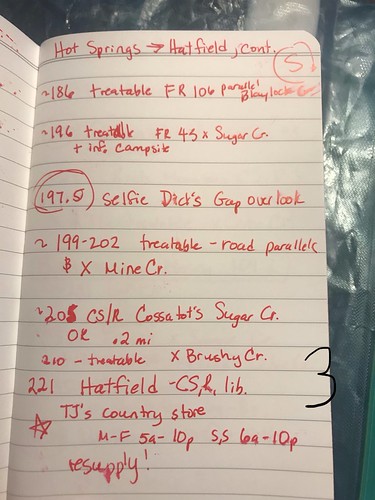
I was thrilled to reach the top of the climb and looked eagerly for the overlook that was our spot for selfie #2. Instead, the road dropped 400 ft in a mile, which is awesome unless you know that you have to ride to a spot high enough to warrant an overlook, in which case a big descent is heartbreaking.
Thankfully the subsequent climb was only half as big, and finally I made it to the Dick's Gap overlook. At least, I assumed it was the correct spot. I didn't see any signs for confirmation, so I crossed my fingers, took a couple pictures, and headed downhill.
After enjoying three miles of downhill (at least, I assume I enjoyed it. It was certainly easier than pushing my bike up another mountain), I filtered water from Mine Creek and began looking for a place to sleep.
Evening facebook post: "Well, I almost made it to 90 after all. Got in 84ish sloooooow miles. So slow. It took me 3.5 hours to go the first 27 easy miles. It was frustrating and embarrassing, but I stayed patient with myself and kept pushing on, walking when I needed to, stopping when I wanted to. It’s not like this is a race — oh wait, it is. But whatever, I can only do what I can do and admire the faster people... About 200 miles down, and now I owe Team Noah Foundation $6 for falling a little short of today’s goal. We’ll see what tomorrow brings...lots of climbing, that’s a given."
84.6 miles - 6,399 ft. elevation gain - 13:57 elapsed time/9:57 moving time
I woke to my 5:00 alarm, happy to discover I hadn't been murdered in my sleep, and began the slow process of packing up the few things I had out of my bags: sleeping clothes, hygiene items, charging cords. I ate the other half of my Parkside PBJ and an apple then reluctantly put on my still-damp kit and rolled my bike into the cool morning air, finally beginning the day's ride at 6:21.
Morning Facebook post: "Day 2: this one’s for Claire and Stacey, but it’s probably going to be considerably shorter than yesterday because of limited sleeping options. Overall I feel pretty good except for my hands, which are already losing some dexterity. A little surprising given the amount of pavement yesterday and the large amount of walking I did on hills and (by the last 10 miles) anything resembling a hill."
As anyone who's my online friend knows, I'd decided to use my race as a fundraiser for the Team Noah Foundation. I shared that my hope was to ride 90+ miles a day and finish in about ten days. Friends (or strangers, I wasn't picky) could pick a day to pledge $1/mile for any miles I rode above the 90, and I in turn would donate $1/mile for any mileage under my target. I'd expected a couple of people to sign on, which was totally fine. It would give me some added motivation on pledged days and bring in a few dollars for the foundation but not be too much pressure.
Instead, within 24 hours all ten days were sponsored, most by multiple people. I'd been excited to pass mile 90 on the first day, securing around $100 in donations by the time I stopped, but the evening food and lodging challenges had made me realize that randomly riding as far as I could without putting a little more thought into where I was going to eat and sleep was a little further into the deep end than I was willing to swim just yet.
 |
| 6:36 a.m. Flat and paved and still soooo slow |
I've done a lot of long rides and races to the point where a 150-mile day no longer sounds outrageous, but I have limited experience with back-to-back long rides and hadn't really understood their unforgiving nature. You can screw up your nutrition for a one-day race with limited consequences, but following a big day with another one will give you immediate feedback on your nutrition and recovery. My body was giving me an emphatic thumbs down.
Despite the easy surface and grade, I was painfully slow. Initial hopes that I just needed an extended warm-up after the previous day receded to eventual acceptance that this glacial pace was all my empty legs had to give. Rather than get upset, I focused on steady progress and kept moving forward.
Alex caught up with me about 90 minutes into the morning and we rode together for a while. I told him how my hands were getting numb, and he mentioned that he made an effort to keep his hands light on the handlebars. I'd been making an effort to change my hand position frequently and to not grip the bars tightly, but the idea of keeping my weight off of my hands finally clicked. The company was nice, but his easy pace still had me pushing harder than I wanted to, so eventually on a hill I dropped back. I wouldn't spend much more time with Alex during the race, but his advice continued to stick with me and help me.
 |
| 8:29 a.m. |
 |
I reached Mt. Ida around 10 a.m. and, still not having learned my lesson about taking advantage of services when I see them, bypassed a grocery store and gas station in search of a breakfast cafe which, when I finally reached it, was closed. Thankfully, a nearby Subway was open. I bought a sandwich to eat right away and a ham and cheese to have later. After lingering over my belated breakfast for way too long, I backtracked half a mile to the closest convenience store, loaded up on expensive junk, and set off again.
 |
| 11:42 a.m. |
 |
| 2:04 p.m., around mile 56 Time to get some fresh water! |
Miles 52-62 followed a generally downhill trend along the absolutely gorgeous Little Missouri River. I passed waterfalls and swimming holes, thinking what a fun spot this would be to stop and hang out. It seemed like half the population of Texas agreed with me as car after car with out of state plates passed me on the gravel. Sometimes it was good motivation not to walk a hill in front of "civilians", sometimes it was super annoying to choke on the road dust their big wheels kicked up, and sometimes it was great fun to ride downhill faster than the cars were willing to drive -- that is, until I'd get caught up in their dust clouds again.
The route took me through the now closed Albert Pike Recreation Area, which was scenic but a little spooky even in the daylight. I stopped to use an actual bathroom at a busy little day use area, then started up a steep climb. I didn't make it far before I was pushing my bike.
That shorter climb and subsequent downhill were followed by ten miles of climbing on Buckeye Mountain. Some of it I could ride, some of it I walked. OK, a lot of it I walked, but a figurative high point was when I was riding. A woman and little girl on an ATV came up behind me and were all impressed, which was a good feeling.
Their group passed me a few times and were really nice and friendly. One of the guys checked if I needed anything, then mentioned they'd seen other riders too. "They're way ahead of you. Like, they were at the overlook a couple hours ago."
I was thrilled to reach the top of the climb and looked eagerly for the overlook that was our spot for selfie #2. Instead, the road dropped 400 ft in a mile, which is awesome unless you know that you have to ride to a spot high enough to warrant an overlook, in which case a big descent is heartbreaking.
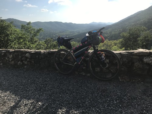 |
| 6:20 p.m., around mile 75 Dick's Gap selfie spot |
 |
| Thrilled to finally be at the top. |
It wasn't late and Hatfield and its convenience store were less than 30 miles away, but reaching the next camping option after Hatfield would have required 50 more miles for the day, more than I wanted. Plus that was an informal campsite, which weren't always easy to find, especially in the dark. Instead I decided to look for the closest informal campsite on my map. If I couldn't find that, I still had one more camping option.
I initially missed the turn and had to use the ACA app (which would show your location on the map) to find the correct road. Then, in the words of my evening Facebook update, "I spent probably 45 minutes walking down a stupid forest road looking for a stupid dispersed campsite, finding nothing better than a big weedy field. 'C’mon, suck it up,' I told myself. 'This is where you’re staying.' A moment later myself replied, 'nope' and we were off in search of the one (hopefully better) other dispersed site in the next 10 miles."
This was a real low point for me. Wandering up and down that shitty road, torn between "I should just turn around" and "maybe the site is just further up", unable to find a site, nervous about sleeping alone (and I hadn't even seen any bears yet!)...it all just combined into a general feeling of what made me think I could do this?
I gave up on the site, if it was there at all (which, by the way, is a good lesson: just because there's a site marked on your map doesn't mean you can find it or that you'll want to stay there) and began following the route towards the remaining mapped site. As I was about to make my next turn, a couple in a golf cart drove up. “There you are! Your friends were worried about you! They thought you’d crashed.”
I looked at them blankly, but they continued. "You're staying in a cabin just up the road. We'll go tell them you're coming."
Alex and Mikey already had a 4-bunk cabin rented, and Alex had picked me up a pulled pork sandwich before the restaurant there closed.
I'd been alone all day, and overall I'd been fine with it. I spend a lot of time by myself on rides because my main training partner is WAY faster than me -- which it turns out was great training for this race -- and I'd been so slow all day that I'd been glad no one was stuck waiting on me or frustrated with me. But now hearing that people I barely knew were looking out for me made me tear up. It was the first time I cried during the race and certainly not the last.
 |
| Home sweet home for the night. |
The cabin was air conditioned, and there was a showerhouse and laundry facility. We didn't have any detergent but were at least able to rinse our filthy kits in the washing machine. Before bed we took a short hike to the closed restaurant to take advantage of its wi-fi, where I was able to text Jacob an update: "Let your dad know I'm staying in a cabin with two guys I met in the race." My point was that I was saving on lodging costs, but it's a testament to my husband's faith in me that this kind of message is neither rare nor troubling.
Evening facebook post: "Well, I almost made it to 90 after all. Got in 84ish sloooooow miles. So slow. It took me 3.5 hours to go the first 27 easy miles. It was frustrating and embarrassing, but I stayed patient with myself and kept pushing on, walking when I needed to, stopping when I wanted to. It’s not like this is a race — oh wait, it is. But whatever, I can only do what I can do and admire the faster people... About 200 miles down, and now I owe Team Noah Foundation $6 for falling a little short of today’s goal. We’ll see what tomorrow brings...lots of climbing, that’s a given."


Comments
Post a Comment