No Sleep 30 hour part 2
It was 3:20 a.m. on race day. After a nightmare pre-race, Chuck and I had just enjoyed a pretty smooth first bike leg and were excited to set off on our initial trek. We bid a cheerful goodbye to the volunteers at TA1 and hit the trails.
Trek (CPs 4-13 any order) -- 13 miles
We'd sketched out about the first half of the bike legs before leaving the pre-race meeting, but route planning for this first trek had been a casualty of our car trouble. With our pre-race time taken up by the simple act of getting to the race, we decided to figure the trek out when we got there. Perhaps if we'd had a little more time to look at the map we'd have decided that attacking the course in a counter-clockwise manner made most sense. But we didn't.
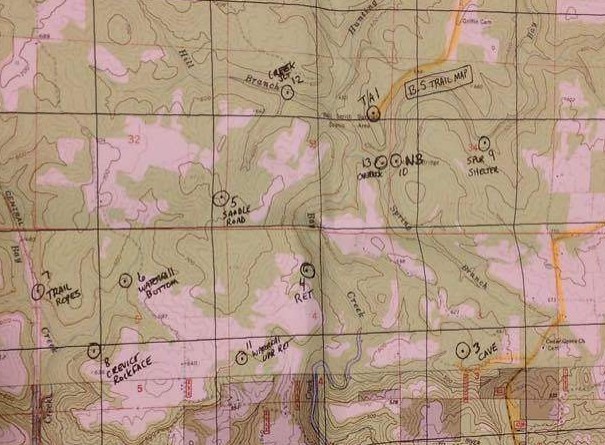
We set off in the early morning darkness in high spirits. In addition to our main map (pictured above), we had supplemental maps of the Bell Smith Springs and Jackson Falls trail systems. With most of the CPs located on or very near the trails, neither of us anticipated any major problems.
via GIPHY
While all checkpoints were optional, the course wasn't exactly a free-for-all. John and Brian had announced at the pre-race meeting that, in order to be considered official finishers, teams would have to visit all TAs. In effect, this made all bike legs on a bike-heavy course mandatory, which in turn meant that we'd need to manage our time in order to leave ourselves the space to do 84 bike miles.
As we trekked, we tried to guesstimate how much time we'd need to reserve for the remaining bike legs so we'd know when we needed to be back at TA1. Deciding 8 mph was a safe guess (faster pace on roads diluted by what was certain to be a far slower pace on trails) meant we'd need to set aside at least 7-8 hours for our bike time. I advocated for a wider margin of safety, knowing we could use any remaining time on the ten checkpoints waiting back near safety of the finish line.
We headed to CP9 first, following upper part of the Sentry Bluff trail around to the location of our CP. As so often happens, following the trail wasn't nearly as clear-cut as it appears on a map ("hey, here's another unmarked trail junction!"), but Chuck did a great job of keeping us on track while I followed behind, gingerly testing my footing on the wet rock.
While nervous about slipping and falling off the bluffs, I was relieved about a different worry. "I'm really glad we're doing this at night," I told Chuck, "when all the snakes are in their snakey little beds."
I laughed about "snakey little beds" for the rest of the race. And now, reading about it again, I don't think I'm done laughing yet.
About halfway around we bid goodbye to dry feet at a fast-moving creek crossing and then began climbing up and, as we hit the big reentrant where the point was plotted, watching for it. Chuck mentioned a few times that we might have gone too far, but we kept going on, just in case, until he realized we'd definitely missed it. By that time we were well past it and over an hour into our trek. Since we were already closer to the next CP (natural bridge) than the one we'd missed and weren't exactly sure where we'd missed it and knew we weren't going to be clearing the course, I pushed to skip it and move on. Not an auspicious start, but surely the next checkpoint wouldn't play so hard to get.
We next headed towards CP10, a relatively short jaunt further down the trail on/under a natural bridge. Assuming that the point was on top, we followed the high trail what seemed like long enough with no success. It looked like a pretty short trek on the map, so we started to worry that we'd overshot another one. Maybe it was underneath. We continued along the trail for a little more before turning around, a decision reinforced by swarming ground hornets (that's what someone else called them, anyway). They didn't sting, but being repeatedly dive-bombed by huge insects was unsettling.
We retraced our steps to the lower trail, watching for the underside of the natural bridge, a task complicated by the fact that we couldn't see past the glow of our headlamps. Look at the map, peer off to either side, move forward, repeat. Eventually we found ourselves climbing back up the other side of the trail, near the top of which Chuck spotted a metal handle and ladder rungs leading down the side of the cliff. I got a sick feeling in my stomach, terrified that we were going to have to climb down.
Chuck took a few steps and slipped on the wet rock surface, landing way too close to the edge for my comfort. Finally, just a bit past that spot, we found team Wickaway enjoying a morning snack at the checkpoint. Boy, we'd made that way harder than it should have been. "Seen any snakes?" they asked us.
"Um, no..."
"Well, be careful. We saw a copperhead and so did another team."
This was the opposite of welcome news. What happened to the snakes in their snakey beds? What happened to snakes sunning themselves in the...sun? This was total bullshit. But at least now we had a trekking point.

Three hours of trekking to get one checkpoint. We needed to pick things up a bit. Thankfully, the sun was starting to rise, and things had to get easier with the light, which was a good thing because now in addition to being worried about falling off a cliff I was also newly afraid of snakes.
Our next destination was CP13 (overlook), which was just a short trip across the creek and then uphill. Luckily, in our circumnavigation of the Natural Bridge trail, we'd already located the creek crossing to take us to CP13. Even luckier, as we headed there I spotted a closer creek crossing, one where we could keep our feet, which had almost dried, out of the water. For all of you AR newbies, let me give you a route-finding hint: if there's an easier way or a harder way, the easier way is probably wrong.
Our feet did stay dry, but that wasn't the way to the CP, so we retraced our steps back across the dry creek crossing, found the correct (wet) creek crossing, and followed the trail to a super cool staircase and then (hallelujah!) checkpoint 13.
Another well chosen checkpoint location that No Sleep used to show off this great area.
We were not doing ourselves any favors on nav, and I felt responsible. I was in the lead when Chuck had mentioned a couple times that he thought we'd gone too far on our search for CP9, and while I didn't push to keep going forward I was definitely happier with the thought that it was just further along the trail than we'd initially thought (which was wrong on the search for CP9 but exactly the case when we turned away too soon on the way to CP10). And of course it was my idea to cross the creek at the spot where we could stay dry.
I resolved to follow behind Chuck, not make any more (bad) suggestions, and listen better when he thought something was wrong. It may have only been coincidence, but from here things got better. We navigated smoothly via trail to CP12 (creek junction), a really cool spot.
We crossed the creek and took the trail, then bushwhacked until we hit the "road", a semi-mowed grassy swath of doubletrack. The road ended up running into/along a field lined with tree stands, and while it was smooth going in the field I refused to walk there because I was afraid it was private property. Instead, we did more bushwhacking in the woods paralleling the field. Thankfully the vegetation was far more forgiving than in northwestern Illinois.
Chuck led us right to CP5 (road/saddle) and then shot a bearing towards CP6 (waterfall bottom, which we both read simply as "waterfall"). We happened along another "road" (maybe in a former life) that led in the general direction of our bearing, making travel much easier. It dumped us out on the remains of a gravel road, and we took a little time to figure out where we needed to go from there.
This was another of those times when I'm thankful that a) Chuck knows what he's doing and b) I kept my mouth shut, because I was pretty convinced -- based on the fact that I might have seen a trail as we hiked down -- that we were totally going the wrong way. Not shockingly, the person holding the map actually had a better idea of where things were, and we, 361 Adventures, and Wickaway all converged on the trailhead at about the same time.
Chuck and I quickly set off down the trail to the waterfall, reaching the top only to discover that the CP was at the bottom...something noted both on our race notes and even on the map. Some guys were swimming in the water at the base of the fall, so I called down to ask them the easiest way to get down there. They suggested climbing down on the spikes driven into a tree in front of the falls or driving partway around and then hiking down. "We're on foot," we told them.
"Oh," they were stymied. "It's a really long way."
Clearly the waterfall CP wasn't happening at this point, so we continued on to CP7, the rappel. I was very not excited about this, and as our trail followed the cliffline and I got a good view of the rock faces I was even less happy. "We're really high. This is really high. Look how high up we are." Like a good teammate, Chuck ignored my complaining and just kept leading me towards potential doom.
Nothing stokes my fear hyperbole like a ropes section, and I'd been particularly nervous about this one because it would be my first rappel without the watchful eyes of my friends at Thunder Rolls/Lightning Strikes. In fact, the one question I'd had for the race directors was about the qualifications of the ropes volunteers. Into whose hands would I be putting my life? Learning that the ropes would be manned by Brian from Vertical Excape Climbing Center made me feel much better. It was his job to know this stuff.
My confidence in the volunteer was scant consolation as we reached his station and got into our harnesses. Compounding my nerves was the new harness I'd bought to avoid lugging the bulk of my normal one for the entire race. I knew it was perfectly good, but all my previous ropes experience has been while wearing the other one. We have a history of not dying together.
Usually at Camp Benson the worst part is going over the edge and then I feel slightly better. This time going over the edge wasn't awful. There were several feet of wall that I could walk down before I got to the overhang, but then it was a freefall. I don't know what my issue is with freefall rappels; it's not like you're actually falling. I inched my way down the rope, petrified.
At the bottom Chuck told me, "I could hear you talking to yourself the whole way down, but I couldn't make out any words. It just sounded like whimpering. What were you saying?"
"It was whimpering," I admitted.
I wish I would have gotten video with sound instead of just the pictures. The wimpering was surprisingly loud, maybe there was some weird acoustics going on with that grotto.
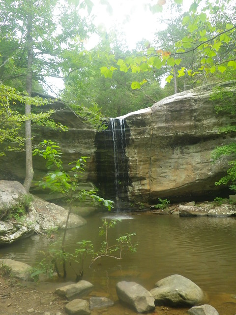
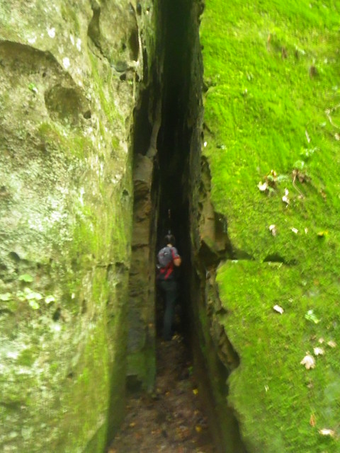
We followed the cliffline to the base of the waterfall, where we snagged CP6, then continued on to our final low CP (crevice-rock face), which was another really cool spot.
We still had three CPs on this leg: CP10, which we'd missed, and CPs 4 and 11, which were roughly on our way back to the TA. We talked briefly about going after 11, but with our bike cushion firmly in mind decided to hold to our self-imposed schedule and go directly back to the TA. We had a lot of race still ahead of us and plenty of other checkpoints to chase.
From here we made our way back to the falls trailhead and reversed our course to CP5, then back towards 12. On the trails near CP12 we encountered a group of hikers who were really curious about the race. Naturally we stopped for a few minutes to explain adventure racing, and I think we might have gained some converts because we could hear them talking about finding a race as we hurried away.
We made it back to TA1 before 2:00 and then had another leisurely transition. Both of us had run out of water towards the end of our trek back and were very happy to fill up at the TA. I'd been trekking in the same damp socks since that first creek crossing, so my main priority was getting some dry socks on. My feet were pretty pruny. I was thrilled to get off my feet, but after 10.5 hours of trekking in bike shorts, I'd developed some pretty uncomfortable chafing. That was going to make for a super fun next bike leg.
(to be continued...on to part 3)
Trek (CPs 4-13 any order) -- 13 miles
 |
| Main map |
We set off in the early morning darkness in high spirits. In addition to our main map (pictured above), we had supplemental maps of the Bell Smith Springs and Jackson Falls trail systems. With most of the CPs located on or very near the trails, neither of us anticipated any major problems.
via GIPHY
While all checkpoints were optional, the course wasn't exactly a free-for-all. John and Brian had announced at the pre-race meeting that, in order to be considered official finishers, teams would have to visit all TAs. In effect, this made all bike legs on a bike-heavy course mandatory, which in turn meant that we'd need to manage our time in order to leave ourselves the space to do 84 bike miles.
As we trekked, we tried to guesstimate how much time we'd need to reserve for the remaining bike legs so we'd know when we needed to be back at TA1. Deciding 8 mph was a safe guess (faster pace on roads diluted by what was certain to be a far slower pace on trails) meant we'd need to set aside at least 7-8 hours for our bike time. I advocated for a wider margin of safety, knowing we could use any remaining time on the ten checkpoints waiting back near safety of the finish line.
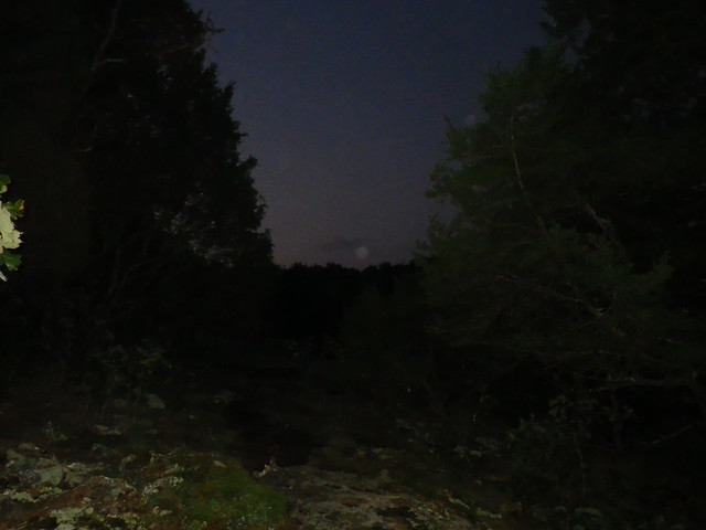
We headed to CP9 first, following upper part of the Sentry Bluff trail around to the location of our CP. As so often happens, following the trail wasn't nearly as clear-cut as it appears on a map ("hey, here's another unmarked trail junction!"), but Chuck did a great job of keeping us on track while I followed behind, gingerly testing my footing on the wet rock.
While nervous about slipping and falling off the bluffs, I was relieved about a different worry. "I'm really glad we're doing this at night," I told Chuck, "when all the snakes are in their snakey little beds."
I laughed about "snakey little beds" for the rest of the race. And now, reading about it again, I don't think I'm done laughing yet.
About halfway around we bid goodbye to dry feet at a fast-moving creek crossing and then began climbing up and, as we hit the big reentrant where the point was plotted, watching for it. Chuck mentioned a few times that we might have gone too far, but we kept going on, just in case, until he realized we'd definitely missed it. By that time we were well past it and over an hour into our trek. Since we were already closer to the next CP (natural bridge) than the one we'd missed and weren't exactly sure where we'd missed it and knew we weren't going to be clearing the course, I pushed to skip it and move on. Not an auspicious start, but surely the next checkpoint wouldn't play so hard to get.
We next headed towards CP10, a relatively short jaunt further down the trail on/under a natural bridge. Assuming that the point was on top, we followed the high trail what seemed like long enough with no success. It looked like a pretty short trek on the map, so we started to worry that we'd overshot another one. Maybe it was underneath. We continued along the trail for a little more before turning around, a decision reinforced by swarming ground hornets (that's what someone else called them, anyway). They didn't sting, but being repeatedly dive-bombed by huge insects was unsettling.
We retraced our steps to the lower trail, watching for the underside of the natural bridge, a task complicated by the fact that we couldn't see past the glow of our headlamps. Look at the map, peer off to either side, move forward, repeat. Eventually we found ourselves climbing back up the other side of the trail, near the top of which Chuck spotted a metal handle and ladder rungs leading down the side of the cliff. I got a sick feeling in my stomach, terrified that we were going to have to climb down.
Chuck took a few steps and slipped on the wet rock surface, landing way too close to the edge for my comfort. Finally, just a bit past that spot, we found team Wickaway enjoying a morning snack at the checkpoint. Boy, we'd made that way harder than it should have been. "Seen any snakes?" they asked us.
"Um, no..."
"Well, be careful. We saw a copperhead and so did another team."
This was the opposite of welcome news. What happened to the snakes in their snakey beds? What happened to snakes sunning themselves in the...sun? This was total bullshit. But at least now we had a trekking point.

Three hours of trekking to get one checkpoint. We needed to pick things up a bit. Thankfully, the sun was starting to rise, and things had to get easier with the light, which was a good thing because now in addition to being worried about falling off a cliff I was also newly afraid of snakes.
 |
| 6:27 a.m. leaving CP10 |
 |
| We took the blue line from CP10, crossed the creek too early, and ended up on the wrong side. |
Another well chosen checkpoint location that No Sleep used to show off this great area.
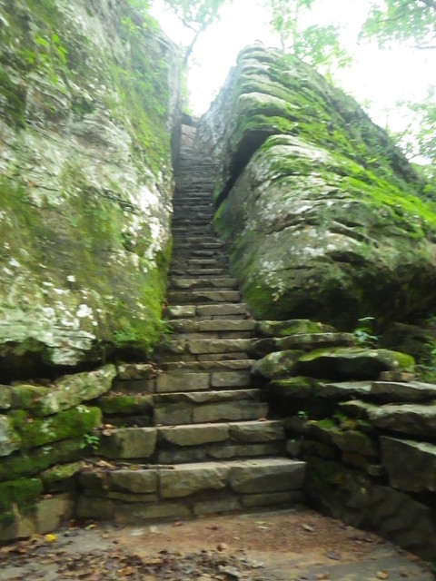 |
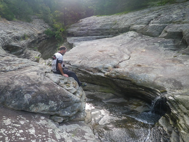
| Stairway to heaven? No, but it did lead to a checkpoint, which is the next best thing. (7:39 a.m.) |
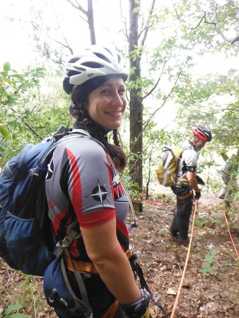
I resolved to follow behind Chuck, not make any more (bad) suggestions, and listen better when he thought something was wrong. It may have only been coincidence, but from here things got better. We navigated smoothly via trail to CP12 (creek junction), a really cool spot.
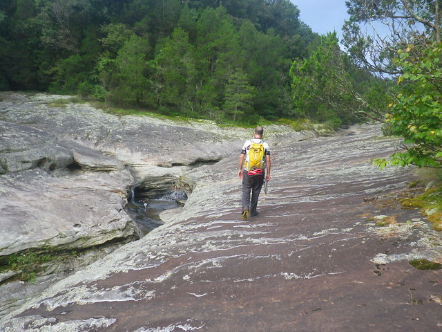 |
| You can see the other creek coming in to Chuck's left. (8:22 a.m.) |
 |
| The control is just below his feet. So pretty! |
Chuck led us right to CP5 (road/saddle) and then shot a bearing towards CP6 (waterfall bottom, which we both read simply as "waterfall"). We happened along another "road" (maybe in a former life) that led in the general direction of our bearing, making travel much easier. It dumped us out on the remains of a gravel road, and we took a little time to figure out where we needed to go from there.
This was another of those times when I'm thankful that a) Chuck knows what he's doing and b) I kept my mouth shut, because I was pretty convinced -- based on the fact that I might have seen a trail as we hiked down -- that we were totally going the wrong way. Not shockingly, the person holding the map actually had a better idea of where things were, and we, 361 Adventures, and Wickaway all converged on the trailhead at about the same time.
Chuck and I quickly set off down the trail to the waterfall, reaching the top only to discover that the CP was at the bottom...something noted both on our race notes and even on the map. Some guys were swimming in the water at the base of the fall, so I called down to ask them the easiest way to get down there. They suggested climbing down on the spikes driven into a tree in front of the falls or driving partway around and then hiking down. "We're on foot," we told them.
"Oh," they were stymied. "It's a really long way."
Clearly the waterfall CP wasn't happening at this point, so we continued on to CP7, the rappel. I was very not excited about this, and as our trail followed the cliffline and I got a good view of the rock faces I was even less happy. "We're really high. This is really high. Look how high up we are." Like a good teammate, Chuck ignored my complaining and just kept leading me towards potential doom.
Nothing stokes my fear hyperbole like a ropes section, and I'd been particularly nervous about this one because it would be my first rappel without the watchful eyes of my friends at Thunder Rolls/Lightning Strikes. In fact, the one question I'd had for the race directors was about the qualifications of the ropes volunteers. Into whose hands would I be putting my life? Learning that the ropes would be manned by Brian from Vertical Excape Climbing Center made me feel much better. It was his job to know this stuff.
 |
| I'm smiling, but I don't mean it. |
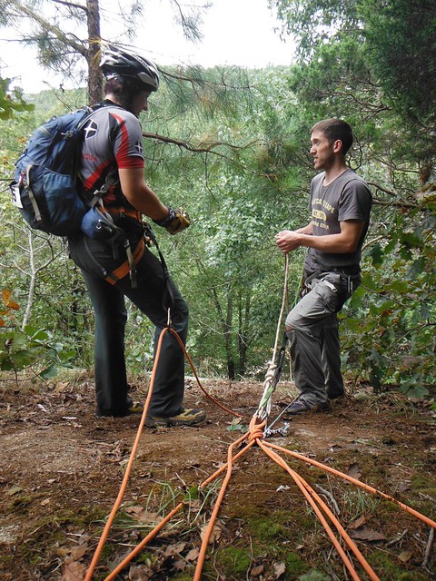 |
| Last-minute instructions from Brian. |
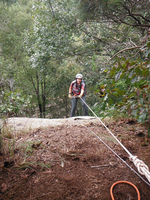 |
| I told the other Brian, "One day I'm going to have a picture on the rappel where I don't have a look of stark terror on my face." He replied, "Smile. Today is that day." |
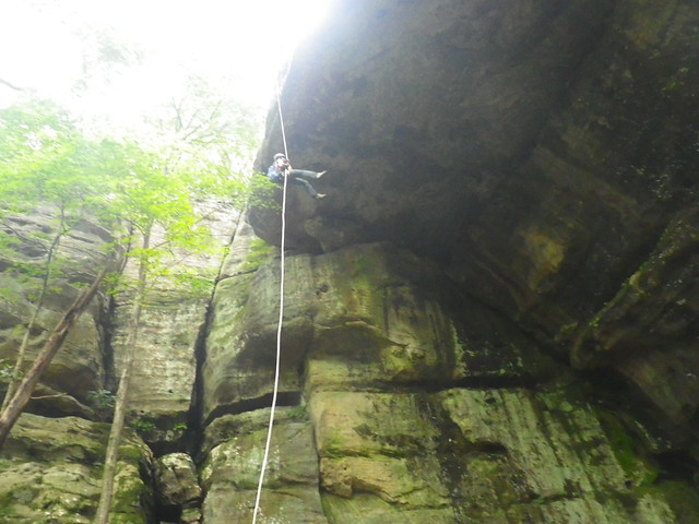 |
| Coming down... (10:55 a.m.) |
"It was whimpering," I admitted.
I wish I would have gotten video with sound instead of just the pictures. The wimpering was surprisingly loud, maybe there was some weird acoustics going on with that grotto.
 |
| 11:28 a.m. |
 |
| 12:02 p.m. |
From here we made our way back to the falls trailhead and reversed our course to CP5, then back towards 12. On the trails near CP12 we encountered a group of hikers who were really curious about the race. Naturally we stopped for a few minutes to explain adventure racing, and I think we might have gained some converts because we could hear them talking about finding a race as we hurried away.
We made it back to TA1 before 2:00 and then had another leisurely transition. Both of us had run out of water towards the end of our trek back and were very happy to fill up at the TA. I'd been trekking in the same damp socks since that first creek crossing, so my main priority was getting some dry socks on. My feet were pretty pruny. I was thrilled to get off my feet, but after 10.5 hours of trekking in bike shorts, I'd developed some pretty uncomfortable chafing. That was going to make for a super fun next bike leg.
(to be continued...on to part 3)


Comments
Post a Comment