No Sleep 30 Hour part 3: Bermuda Triangle
Note: If you're just starting this saga, you're going to want to first check out our prologue, part 1, and part 2 to get caught up with the action.
Chuck and I had just trekked for about 10.5 hours, spending the majority of that time with wet feet. I had extra socks but didn't want to waste them in damp shoes. By the time we arrived back at TA1, slipping my pruney feet into dry socks and bike shoes was sweet, sweet relief.
Bike to TA2/Road-trail junction (CPs 14-19 in order) -- 24(?) miles
I was thrilled to give my sore feet a break on the bike leg right until I lowered myself onto the saddle and realized just how chafed I was from trekking all that time in bike shorts. While not (yet) agonizing, it wasn't pleasant. We took gravel roads to the road/trail intersection where we found CP14 (lower left-hand corner on map below). From there the trail diverged: singletrack to the left, doubletrack to the right; with apologies to Mr. Frost, we took the path more traveled, because it was faster and easier.
Back on track in this Bermuda Triangle trail system, we set off towards CP17 with renewed hope, locating the correct trail just a bit behind the weird bike statue thing and heading east. As we navigated mud bogs, creek crossings, rocks, and log jams, our confidence in the trail waned, but since it was going in the right direction we proceeded along, stopping frequently to question ourselves.
Chuck started mentioning that he thought we'd gone too far. Given our recent history, it was a real toss-up. We'd kept going once when he was right about going too far, and we'd turned around just a bit too soon when we'd mistakenly thought we were too far. We kept going forward in the hopes we needed to just go a little further, but the sun was getting lower, and as much as I'd struggled on these trails in the daylight I really, really didn't want to still be on them in the dark.
Eventually we retreated to our known location (the one-eyed biker CP) to reattack. There we sat down with the map. We weren't sure where we'd gone wrong, and the sun continued its downward trajectory. Looking up the steep, rocky road leading north from the checkpoint I asked, "Can that help us get the hell out of here and bail onto roads before it gets dark?" Yes, it could. Bailing meant extra mileage and missing checkpoints 17-19, but at this point those were no sure thing and (that same old refrain) we knew we weren't going to clear the course anyway.
My relief was quickly overshadowed by the fact that our escape route required riding 195 miles (that may be a slight exaggeration) uphill on a "road" paved with chunky rock. Not big river gravel, these were more like cobblestones from hell. We reached the summit and turned onto an actual gravel road just before I could give in to tears. Thankfully, from that point on the roads became much more rideable; that, in combination with actually knowing where we were, was a huge lift.
We certainly didn't pick the flattest way to bypass the rest of the single-track. At one point we were grinding up some giant hill, and an on-coming pickup truck slowed to a stop next to us and rolled down the driver side window: "If ya'll wanna grab onto my tailgate, I'll give you a tow to the top." Such friendly people in the Shawnee Forest!
Lol! I'd forgotten all about that. And there were also the two girls we ran into by the waterfall checkpoint on the trek who asked if we were with the race. When we said we were, they offered, "Do you want some help?"
Simultaneously, one of us answered, "Yes!" and the other said, "No!" They gave us a funny look and walked off.
Stopping at an intersection, we attracted the attention of an older lady who was just coming home. Seeing us looking over the maps, she offered help. "Where are you trying to get?"
We were navigating by a topographical map with no road names, riding towards a road/trail junction more or less in the middle of nowhere. Try explaining that to someone unfamiliar with adventure racing. "Hartsville," Chuck answered, pulling a name off the map.
"Well, I don't know where that is," she replied. "But this is such and such road, and you can take it a couple miles to 145."
"That's off limits," we told her. She looked at our maps with the blank confusion I generally feel and repeated, "This is such and such road." We thanked her for her "help" and rode away.
She was so funny and well intentioned. After announcing how she'd lived here all her life, we discovered her local geography was limited to the name of the road we were standing on and little else. Luckily, we had a good grasp on the navigation again and didn't have to rely on her kindly help.
Despite the fact that we were totally winging it, Chuck did a fantastic job navigating our impromptu route. No longer preoccupied with fear of being doomed to wander Shawnee singletrack for eternity, I was reminded just how uncomfortably chafed I was, but when I wasn't wincing in pain on the saddle I was appreciating just how beautiful our surroundings were and feeling glad that, whatever I'd told Chuck during Thunder Rolls about skipping this race, we'd decided to make the trip.
We didn't quite make it to the TA before night fell, so we made a quick stop on the road to pull out headlamps and jackets against the rapidly falling temperature and then rode into TA2 just before 8 p.m. At 20 hours into the race we still had another 10 to go and lots of course left. But first, we had to finally get to that route planning.
...to be continued...
Chuck and I had just trekked for about 10.5 hours, spending the majority of that time with wet feet. I had extra socks but didn't want to waste them in damp shoes. By the time we arrived back at TA1, slipping my pruney feet into dry socks and bike shoes was sweet, sweet relief.
Bike to TA2/Road-trail junction (CPs 14-19 in order) -- 24(?) miles
I was thrilled to give my sore feet a break on the bike leg right until I lowered myself onto the saddle and realized just how chafed I was from trekking all that time in bike shorts. While not (yet) agonizing, it wasn't pleasant. We took gravel roads to the road/trail intersection where we found CP14 (lower left-hand corner on map below). From there the trail diverged: singletrack to the left, doubletrack to the right; with apologies to Mr. Frost, we took the path more traveled, because it was faster and easier.
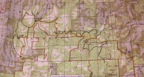 |
| Our intended route is highlighted in orange. |
We followed the doubletrack until the turn for CP15 (reentrant), a quick singletrack out-and-back made longer by some seriously muddy sections of trail. Pedal, pedal, splat. Pedal, pedal, walk. Before long I managed to bury my foot in the slop; my long-anticipated dry socks had lasted maybe an hour.
After finding 15 without incident, we retraced our steps and proceeded towards 16, described on the clue sheet as "creek trail junction (one-eyed biker)". Probably reading that information with a mental whatever the hell that means while plotting, we'd only noted the junction on our map. And speaking of the map, our route looks pretty straightforward when you look at that map I posted. Looks being the operative word.
I didn't know about the one-eyed biker clue until I read this!
Um....oops?
While the trail overlays on the map are (apparently...you certainly couldn't prove it by us) accurate because they're taken from the race directors' GPS data, what the map doesn't reflect is other trails weaving across the terrain. Some were labeled with numbers, some weren't. It made my head hurt, and I pretty quickly checked out mentally from trying to have any clue where we were. The trails were muddy, rocky, and horsed-up; I really wasn't feeling it at the time and went through a low spot mentally as I struggled to maintain any momentum on the trails. I wish Bob or Lo was here with Chuck; he'd be having so much more fun with them on these trails. Why am I so bad at this? I'm the worst BEST race partner ever.
We reached the creek/trail junction where Chuck thought the CP would be. No luck. We explored to our right where the trail sort of ran into the creek and then petered out in a big gravel bar/logjam. Nothing. We backed up and crossed the creek at the original intersection, somewhat stymied when the trail split again soon after. Somewhere around here Chuck, looking blankly at the map, muttered, "I don't know where we are...or where the checkpoint is...or what to do." I greeted this admission with one part quiet depression, one part cheerful confidence that he'd get it sorted out, and no parts help of any kind.
We took the high side of the split (is this right, Chuck? I don't know) and continued on to yet another creek crossing. While Chuck looked at the map, I glanced across the creek and spotted (oh, joy!) a cyclist sitting or standing near his bike. "Look! Maybe that guy knows his way around here," I said. "Let's go ask him."
As Chuck got closer, he turned back towards me and mouthed, "This is going to get weird."
The 'guy' hadn't moved a muscle in the whole time we'd been talking and walking toward him. Then I noticed the walker behind him...wtf?
Our would-be savior turned out to be some beat up mannequin/statue thing with two ramshackle bikes beside it. Walking around it to take in all the crazy, Chuck exclaimed, "No way!" and held out a CP marker.
"Which one is it?" I asked.
"16."
Somehow, despite having no clue where we were, we'd stumbled across the very checkpoint we were searching for.
After getting back home, a night of sleep, and a couple of meals, I took another look at the map for this area. Details that I missed during the actual race jumped out at me in perfect clarity. I really want to go back and re-ride that section.
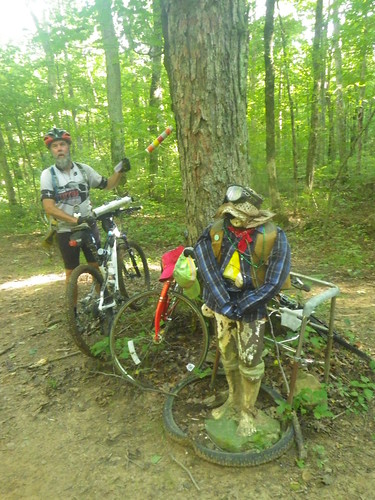 |
| One-eyed biker...now the clue I hadn't read made sense. (4:53 p.m.) |
Chuck started mentioning that he thought we'd gone too far. Given our recent history, it was a real toss-up. We'd kept going once when he was right about going too far, and we'd turned around just a bit too soon when we'd mistakenly thought we were too far. We kept going forward in the hopes we needed to just go a little further, but the sun was getting lower, and as much as I'd struggled on these trails in the daylight I really, really didn't want to still be on them in the dark.
Eventually we retreated to our known location (the one-eyed biker CP) to reattack. There we sat down with the map. We weren't sure where we'd gone wrong, and the sun continued its downward trajectory. Looking up the steep, rocky road leading north from the checkpoint I asked, "Can that help us get the hell out of here and bail onto roads before it gets dark?" Yes, it could. Bailing meant extra mileage and missing checkpoints 17-19, but at this point those were no sure thing and (that same old refrain) we knew we weren't going to clear the course anyway.
My relief was quickly overshadowed by the fact that our escape route required riding 195 miles (that may be a slight exaggeration) uphill on a "road" paved with chunky rock. Not big river gravel, these were more like cobblestones from hell. We reached the summit and turned onto an actual gravel road just before I could give in to tears. Thankfully, from that point on the roads became much more rideable; that, in combination with actually knowing where we were, was a huge lift.
We certainly didn't pick the flattest way to bypass the rest of the single-track. At one point we were grinding up some giant hill, and an on-coming pickup truck slowed to a stop next to us and rolled down the driver side window: "If ya'll wanna grab onto my tailgate, I'll give you a tow to the top." Such friendly people in the Shawnee Forest!
Lol! I'd forgotten all about that. And there were also the two girls we ran into by the waterfall checkpoint on the trek who asked if we were with the race. When we said we were, they offered, "Do you want some help?"
Simultaneously, one of us answered, "Yes!" and the other said, "No!" They gave us a funny look and walked off.
Stopping at an intersection, we attracted the attention of an older lady who was just coming home. Seeing us looking over the maps, she offered help. "Where are you trying to get?"
We were navigating by a topographical map with no road names, riding towards a road/trail junction more or less in the middle of nowhere. Try explaining that to someone unfamiliar with adventure racing. "Hartsville," Chuck answered, pulling a name off the map.
"Well, I don't know where that is," she replied. "But this is such and such road, and you can take it a couple miles to 145."
"That's off limits," we told her. She looked at our maps with the blank confusion I generally feel and repeated, "This is such and such road." We thanked her for her "help" and rode away.
She was so funny and well intentioned. After announcing how she'd lived here all her life, we discovered her local geography was limited to the name of the road we were standing on and little else. Luckily, we had a good grasp on the navigation again and didn't have to rely on her kindly help.
Despite the fact that we were totally winging it, Chuck did a fantastic job navigating our impromptu route. No longer preoccupied with fear of being doomed to wander Shawnee singletrack for eternity, I was reminded just how uncomfortably chafed I was, but when I wasn't wincing in pain on the saddle I was appreciating just how beautiful our surroundings were and feeling glad that, whatever I'd told Chuck during Thunder Rolls about skipping this race, we'd decided to make the trip.
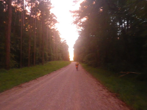 |
| It looks pretty bright in this picture, but sunset was definitely in progress. (7:31 p.m.) |
We didn't quite make it to the TA before night fell, so we made a quick stop on the road to pull out headlamps and jackets against the rapidly falling temperature and then rode into TA2 just before 8 p.m. At 20 hours into the race we still had another 10 to go and lots of course left. But first, we had to finally get to that route planning.
...to be continued...


Comments
Post a Comment