Sophomore year
If you've been reading my blog for long at all, it's no secret that navigation isn't one of my strong points. It's something I really want to improve on, which is why I spent a lot of my Christmas break wandering around in the woods on the Rockwoods Range permanent orienteering course.
Last week we had a brief reprieve from this month's freezing cold. Saturday was absolutely beautiful, and I was lucky enough to spend much of that 60* day outside in the woods. The St. Louis Orienteering Club was hosting an orienteering meet at Cliff Cave park, and this was going to be my second solo attempt. The first, my freshman year, if you will, featured significant amounts of crying.
Alpine Shop's Jeff and Carrie Sona were the meet directors, and there were a few more familiar faces there as well. Of course, that basically meant that, once I saw the map was pre-plotted for us, I spent my pre-race time socializing rather than strategizing. In fact, I didn't even get my compass out until after I'd found the first CP and gotten all turned around after leaving it. But that wasn't even my first mistake.
The meet format was a 90 minute score-o. Basically, you had 90 minutes from your start time to get as many points as possible. All points that were originally mapped were worth 10 points. There were an additional six points that we'd copy onto our maps from maps that were on the course; these were each worth 20 points. Instead of using a paper passport that you literally had to punch with a tool at each checkpoint, this meet was all e(lectronic) punch, so your time began when you punched in at the start.
Well, Jeff S was sitting at the start, so I talked to him about upcoming races before I got going. Unfortunately, I forgot to look at my watch when I punched in, so I only had a vague idea of what my start time was. Since the penalty for returning late was a point a minute, this had the potential to be a big misstep.
CP 1 was pretty easy to find. All you had to do was go up. And UP. It was a pretty steep trail, and though I knew Jacob would have loved scrambling up it, I was a little relieved not to have to worry about him falling off the top.
It looks like it should be a straight shot from 1 to 8, but the easiest things tend to trip me up. Confidence is rarely a good sign when I'm orienteering. I took the trail and immediately got turned around at the first intersection (and I know it looks totally simple as I look at the map now). It was right around this point where I realized my compass was still in my pack, so I got it out and was about to go back to the first CP and reorient myself when Mark jogged by. Pretty sure he knew what he was doing, I opted to go that way and try to figure out where I was on the map (not the best way to operate, but whatever). As I hiked along and squinted at my map, I saw him dash back onto the trail from a CP. Since the CP was marked with its number (8), I now knew where I was.
After that first brief stint as a lost lamb, I managed the rest of the meet on my own. I wouldn't say that I was full of confidence, but with lots of looking at my map and trying (with a fair amount of success) to relate it to what I was seeing in front of me, I made it to 9, 10, and 11 with no major missteps. Alpine Shop's David passed me as I was running to 12; since usually when you see me with a map I'm standing in one place with my brow furrowed, it was a major triumph to be both a) running and b) confident where I was going when he passed. Once I punched 12, I ran back across the field and followed the trail to 2. With that, I was finished with the smaller eastern side of the course and crossed the main road to pick up 3.
I'd been glad the course started on the eastern side because though I've ridden several times at Cliff Cave (it's where Jacob learned to mountain bike) the trails on the western side continue to baffle me. I get all kinds of turned around. Combine that with the fact that the first checkpoints always seem the hardest, and starting on the western side would be a recipe for disaster. Getting my orienteering feet under me didn't stop me from continuing to make mistakes, though.
I went from 3 to 13, figuring I could run the trail and then follow the creek to the CP. That was more or less the case, but the hike along the creek was no easy walk. One mistake I continue to repeat is tunnel vision. I see where I'm going on the map but fail to look at what else the map tells me; in this case, the dark green shading indicating that the area was heavily wooded and difficult to pass through. Granted, there was no other good option to get there, but I wasn't really anticipating the tough going.
From 13 I picked up 4, which was located at the carcass of an old car. Next up was 14, and then I made my next typical-for-me error. Having socialized instead of doing even some minimal route planning (besides "I'm starting with the easier eastern side"), I hadn't really looked at the course as a whole to determine what order of attack made the most sense. Instead, I'd hit a point, then decide where I was going from there. Because of this, I followed 14 with 6.
If you look back up at the map, you'll notice a couple things. First, 6 and 7 (the logical next CP) are right next to the road. What might not be evident because of the way I cropped the picture is that the road leads back to the finish. For someone who has taken the time to plan ahead, 6 and 7 are the natural last two CPs before heading back. Also, due to the steepness around 7 (all those contour lines super close together), the best route to 7 is through 6. Oh well, at least I realized after punching 6 that it didn't really make sense to hit 7 until I was heading back, so from 6 I went to CP5 and then 16, where I copied down the locations of 20, 21, and 22.
At this point, though I wasn't sure exactly how much (if any) time I had left, I knew I was starting to run short. I figured I could get at least 20 and then maybe 17 before heading back. From 16, I hopped back onto the trail, only to get turned around again as soon as I hit an intersection. I was standing there trying to think it through when a couple went past me and down the trail. I started to follow after them, then saw that the trail led out to the school grounds where we usually park to ride, so I backed up, realized that I'd been in more or less the right spot when they had gone past me, and made the quick hike through a marshy area to get CP20.
Back on the trail I briefly headed towards 17, but I knew I was cutting it close on time, so I decided to head back towards the start instead. Once again I got turned around on the trails, but luckily I came across CP5. Knowing where I was for sure, I abandoned the trails and cut straight east, passing CP6 again, quickly jogging to the cave to punch 7, and then running in to the finish. Results haven't been posted yet, but I'm pretty sure I ended up making it in under the time by about 2 minutes.
Really, whether or not I made it in time or not, I consider the day a success. I found 18/22 CPs (an 82%, so it's a C, which is much better than my resounding F two years ago at Babler), had a great day outside in the woods, and got confirmation that my orienteering skills are starting to develop (the contrast between my gps track two years ago at Babler, when I was clearly wandering around in circles, and this year at Cliff Cave, where I may not have gone directly there but was pretty close, is pretty funny...well, it's funny now). I definitely felt more comfortable with the map during our trips to Rockwoods, but I always had somebody else out there doing most of the work. This was the first time I've been on my own when things were clicking (and there was no crying). Now I just need to focus on more practice, better planning, and cutting down on dumb mistakes. I'd like to say less pre-race socializing, but I'm trying to be realistic here.
Last week we had a brief reprieve from this month's freezing cold. Saturday was absolutely beautiful, and I was lucky enough to spend much of that 60* day outside in the woods. The St. Louis Orienteering Club was hosting an orienteering meet at Cliff Cave park, and this was going to be my second solo attempt. The first, my freshman year, if you will, featured significant amounts of crying.
Alpine Shop's Jeff and Carrie Sona were the meet directors, and there were a few more familiar faces there as well. Of course, that basically meant that, once I saw the map was pre-plotted for us, I spent my pre-race time socializing rather than strategizing. In fact, I didn't even get my compass out until after I'd found the first CP and gotten all turned around after leaving it. But that wasn't even my first mistake.
The meet format was a 90 minute score-o. Basically, you had 90 minutes from your start time to get as many points as possible. All points that were originally mapped were worth 10 points. There were an additional six points that we'd copy onto our maps from maps that were on the course; these were each worth 20 points. Instead of using a paper passport that you literally had to punch with a tool at each checkpoint, this meet was all e(lectronic) punch, so your time began when you punched in at the start.
Well, Jeff S was sitting at the start, so I talked to him about upcoming races before I got going. Unfortunately, I forgot to look at my watch when I punched in, so I only had a vague idea of what my start time was. Since the penalty for returning late was a point a minute, this had the potential to be a big misstep.
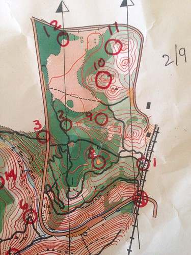 |
| The start/finish is that triangle on the right. I went 1, 8, 9 (where I copied down the locations for 10-12), 10, 11, 12, 2, and then I crossed the road to get 3. |
CP 1 was pretty easy to find. All you had to do was go up. And UP. It was a pretty steep trail, and though I knew Jacob would have loved scrambling up it, I was a little relieved not to have to worry about him falling off the top.
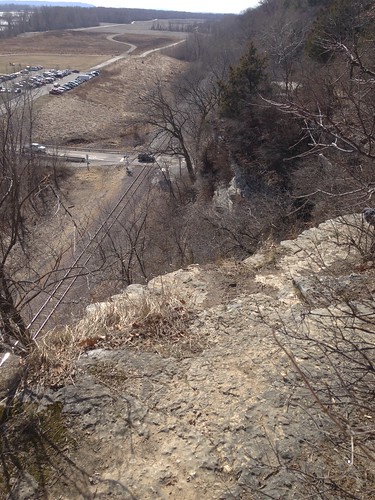 |
| View from CP1 back towards the parking lot |
After that first brief stint as a lost lamb, I managed the rest of the meet on my own. I wouldn't say that I was full of confidence, but with lots of looking at my map and trying (with a fair amount of success) to relate it to what I was seeing in front of me, I made it to 9, 10, and 11 with no major missteps. Alpine Shop's David passed me as I was running to 12; since usually when you see me with a map I'm standing in one place with my brow furrowed, it was a major triumph to be both a) running and b) confident where I was going when he passed. Once I punched 12, I ran back across the field and followed the trail to 2. With that, I was finished with the smaller eastern side of the course and crossed the main road to pick up 3.
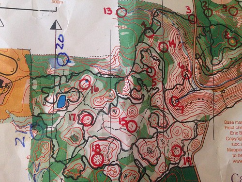 |
| On the western side of the road, my route went 3, 13, 4, 14, 6, 5, 16, 20 |
I went from 3 to 13, figuring I could run the trail and then follow the creek to the CP. That was more or less the case, but the hike along the creek was no easy walk. One mistake I continue to repeat is tunnel vision. I see where I'm going on the map but fail to look at what else the map tells me; in this case, the dark green shading indicating that the area was heavily wooded and difficult to pass through. Granted, there was no other good option to get there, but I wasn't really anticipating the tough going.
 |
| Nice ride |
If you look back up at the map, you'll notice a couple things. First, 6 and 7 (the logical next CP) are right next to the road. What might not be evident because of the way I cropped the picture is that the road leads back to the finish. For someone who has taken the time to plan ahead, 6 and 7 are the natural last two CPs before heading back. Also, due to the steepness around 7 (all those contour lines super close together), the best route to 7 is through 6. Oh well, at least I realized after punching 6 that it didn't really make sense to hit 7 until I was heading back, so from 6 I went to CP5 and then 16, where I copied down the locations of 20, 21, and 22.
At this point, though I wasn't sure exactly how much (if any) time I had left, I knew I was starting to run short. I figured I could get at least 20 and then maybe 17 before heading back. From 16, I hopped back onto the trail, only to get turned around again as soon as I hit an intersection. I was standing there trying to think it through when a couple went past me and down the trail. I started to follow after them, then saw that the trail led out to the school grounds where we usually park to ride, so I backed up, realized that I'd been in more or less the right spot when they had gone past me, and made the quick hike through a marshy area to get CP20.
Back on the trail I briefly headed towards 17, but I knew I was cutting it close on time, so I decided to head back towards the start instead. Once again I got turned around on the trails, but luckily I came across CP5. Knowing where I was for sure, I abandoned the trails and cut straight east, passing CP6 again, quickly jogging to the cave to punch 7, and then running in to the finish. Results haven't been posted yet, but I'm pretty sure I ended up making it in under the time by about 2 minutes.
Really, whether or not I made it in time or not, I consider the day a success. I found 18/22 CPs (an 82%, so it's a C, which is much better than my resounding F two years ago at Babler), had a great day outside in the woods, and got confirmation that my orienteering skills are starting to develop (the contrast between my gps track two years ago at Babler, when I was clearly wandering around in circles, and this year at Cliff Cave, where I may not have gone directly there but was pretty close, is pretty funny...well, it's funny now). I definitely felt more comfortable with the map during our trips to Rockwoods, but I always had somebody else out there doing most of the work. This was the first time I've been on my own when things were clicking (and there was no crying). Now I just need to focus on more practice, better planning, and cutting down on dumb mistakes. I'd like to say less pre-race socializing, but I'm trying to be realistic here.


A great day outside in the woods in 60-degree temps sounds awesome about now. Hell I'd be happy with 30 degrees even. Yay for progress!
ReplyDeleteYou are markedly improved! I still get lost on my own cross street.
ReplyDeleteNice job Kate! 18 of 22 is really good!
ReplyDeleteNice weather makes it nice too.
You are moving up for sure! Progress is great and your attitude is the best. That all would stump me for sure.
ReplyDelete